Interplace
A critical look at the interaction of people and place by an ex-Microsoft pioneer in interaction design.
Brad Weed
Show overview
Interplace has been publishing since 2021, and across the 5 years since has built a catalogue of 168 episodes. That works out to roughly 60 hours of audio in total. Releases follow a fortnightly cadence.
Episodes typically run twenty to thirty-five minutes — most land between 17 min and 24 min — and the run-time is fairly consistent across the catalogue. None of the episodes are flagged explicit by the publisher. It is catalogued as a EN-language Science show.
The show is actively publishing — the most recent episode landed 2 weeks ago, with 8 episodes already out so far this year. The busiest year was 2022, with 45 episodes published. Published by Brad Weed.
From the publisher
Interplace explores the interaction of people and place. It looks at how we move within and between the places we live and what led us here in the first place. interplace.io
Latest Episodes
View all 168 episodesLiving Through Tulsa's Time
The Transit of Two Titans
Becoming Not Beginning
What the World Points To
The Map that Murders and the Mind that Masks
Hello Interactors,This one attempts to balance the privilege of cold analytical escapism with the gruesome rehumanization of past, present, and future atrocities. I end up trying to make sense of the political psychology that leads to such jubilant violence. While it can be understood, its the very intelligibility that makes it so intolerable. PRESSURE, POWER, IMPUNITYIn 1965, as my umbilical cord was being severed in Iowa, U.S. soldiers in Vietnam were cutting the ears off innocent dead Vietnamese children. And their parents. The shriveling cartilage served as “proof” they were killed. They’d string them into necklaces or hoard them in “ear bags” as trophies. Their commanders demanded a tally. This morbid ritual, born from the military’s obsession with numeric “success” metrics amid “search and destroy” orders, exposed not just individual moral depravity but a systemic disregard for human life.Such barbarity serves as just another example of America’s enduring pattern of defying Geneva Conventions on civilian protections, proportionality, and prohibited weapons. These atrocities are wrapped in bureaucratic euphemisms like “collateral damage”; all to evade accountability and perpetuate unchecked imperial violence.When barbarity returned like a boomerang to hit the Twin Towers on 9/11, the term “collateral damage” was absent. But “search and destroy” came back. The 2001 Authorization for Use of Military Force authorizes the president “to use all necessary and appropriate force against those nations, organizations, or persons he determines planned, authorized, committed, or aided the terrorist attacks that occurred on September 11, 2001, or harbored such organizations or persons.” These expanded interpretations of and the idea of a “continuing, imminent threat” led to doctrines that allowed drones and bombs to be used as sanctioned forms of force across borders. Targeted killings are domestic justifications that override attempts at global legal constraints.As my own kids were being born in 2004, U.S. drones were flying across the skies over Afghanistan, Yemen, and beyond, vaporizing wedding parties, schools, and outdoor markets, shredding innocent men, women, and children into mangled flesh mixed with bone fragments. These ‘Hellfire missiles’ were sold to the public as possessing surgical precision. These “precision” killings, justified as “targeted” under the euphemism of “signature strikes,” leave behind charred craters, orphaned survivors screaming amid the rubble, and “double taps” that slaughter first responders rushing to the scene. And here again the body-count calculus of modern warfare dehumanizes the dead as mere “collateral” in an endless cycle of remote-control atrocity.However, unlike in Vietnam, groups controlling casualty numbers and combatant definitions created incentives to undercount civilian deaths to bolster the claims of legal precision. Because such reasoning was long classified, external scrutiny relied on leaks and sporadic court‑ordered disclosures.Obama deployed 10 times more drones than Bush. They all occurred in legal grey zones. They were justified through broad claims of self‑defense against “imminent threats” from non‑state actors operating in countries not formally at war with the United States. Legal assessments have found that many attacks did not meet the threshold of an “armed conflict” — meaning strikes there should have been constrained by international human‑rights law — thus violating requirements of necessity, last resort, and proportionality.Recent incidents, like the Iranian Khamenei killing, further expose gaps between law and practice. In the case of the 2020 killing of Iranian General Soleimani, scholars argue that the official rationale failed to meet the UN Charter’s Article 51 requirement of an actual armed attack. Since then, the U.S. and its allies have instead advanced an even more squishy view of “imminence” to justify anticipatory defense against imagined potential threats. Critics say these interpretations transform what was intended to be a narrow exception into a license for routine, preemptive killing.The U.S. government is seemingly unequaled in its interpretive flexibility of law. Rather than submitting to adjudication, they practice “norm‑shaping” noncompliance. This involves acting first, then using rhetoric and diplomatic influence to normalize or justify those actions. Research on the UN Security Council demonstrates how veto rights, opaque bargaining, and diluted resolutions enable permanent members to escape condemnation while weaker states are disciplined. In effect, international law becomes a language powerful states can manage, not a rulebook to obey.U.S. operations in Iran, Afghanistan, Yemen, Somalia, Iraq, and elsewhere are often positioned as short-term “strikes” meant to sustain “rules-based order.” But the U.S. doesn’t have to behave orderly. Moreover, these actions show a longstanding system where the law on force sustains hegemony
From Microsoft to the Surveillance State
Hello Interactors,Watching all the transnational love at the Olympics has been inspiring. We’re all forced to think about nationalities, borders, ethnicities, and all the flavors of behavioral geography it entails. After all, these athletes are all there representing their so-called “homeland.” And in the case of Alysa Liu, her father’s escape from his. Between the 1989 Tiananmen Square massacre and the fall of the Berlin wall, “homeland” took on new meaning for many immigrants. This all took me back to that time and the start of my own journey at Microsoft at the dawn of a new global reality.HOMELAND HATCHED HEREWith all the focus on Olympics and immigration recently, I’ve found myself reflecting on my days at Microsoft in the 90s. As the company was growing (really fast), teams were filling up with people recruited from around the world. There were new accents in meetings, new holidays to celebrate, and yummy new foods and funny new words being introduced. This thickening of transnational ties made Redmond feel as connected the rest of the world as the globalized software we were building. By 2000 users around the world could switch between over 60 languages in Windows and Office. In behavioral geography terms, working on the product and using the product made “here” feel more connected to “elsewhere.”This influx of new talent was all enabled by the Immigration Act of 1990. Signed by George H. W. Bush, it increased and stabilized legal pathways for highly skilled immigrants. This continued with Clinton era decisions to expand H-1B visa allocations that fed the tech hiring boom. I took full advantage of this allotment recruiting and hiring interaction designers and user researchers from around the world. In the same decade the federal government expanded access to the United States, it also tightened security. Terrorism threats, especially after the 1993 World Trade Center bombing, spooked everyone. Despite this threat, there was more domestic initiated terrorism than outside foreign attacks. The decade saw deadly incidents like the Oklahoma City bombing in 1995 by radicalized by white supremacist anti-government terrorists, which killed 168 and injured hundreds, making it the deadliest terrorist attack in U.S. history before 9/11.A year later, the Atlanta Olympic bombing and related bombings by anti-government Christian extremists caused multiple deaths and injuries. Clinic bombings and shootings by anti-abortion extremists began in 1994 with the Brookline clinic shootings and continued through the 1998 Birmingham clinic bombing. These inspired more arsons, bombings, and shootings tied to white supremacist, anti-abortion, and other extreme ideologies.Still, haven been shocked by Islamist extremists in 1993 (and growing Islamic jihadist plots outside the U.S.) the federal government adopted new security language centered on protecting the “homeland” from outside incursions. In 1998, Clinton signed Presidential Decision Directive 62, titled “Protection Against Unconventional Threats to the Homeland and Americans Overseas,” a serious counterterrorism document whose title quietly normalized the term homeland inside executive governance.But there was at least one critical voice. Steven Simon, Clinton’s senior director for counterterrorism on the National Security Council, didn’t think “Defense of the Homeland” belonged in a presidential directive.Simon’s retrospective argument is that “homeland” did more than name a policy, it brought a territorial logic of legitimacy that the American constitution had historically resisted. He recalls the phrase “Defense of the Homeland” felt “faintly illiberal, even un-American.” The United States historically grounded constitutional legitimacy in civic and legal abstractions (people, union, republic, human rights) rather than blood rights or rights to soil. Membership was to be mediated by institutions, employment, and law rather than ancestry.“Homeland” serves as a powerful cue that suggests a mental model of ‘home’ and expands it to encompass a nation. This model is accompanied by a set of spatial inferences that evoke familiarity, appeal, and even an intuitive sense. However, it also creates a sense of a confined interior that can be breached by someone from outside.This is rooted in place attachment that can be defined as an affective bond between people and places — an emotional tie that can anchor identity and responsibility. But attachment is not the same thing as ownership. Research on collective psychological ownership shows how groups can come to experience a territory as “ours.” This creates a sense of ownership that can be linked to a perceived determination right. Here, the ingroup is entitled to decide what happens in that place while sometimes feeding a desire to exclude outsiders. When the word “homeland” was placed at the center of statecraft it primed public reasoning from attachment of place through care, stewardship, and shared fate toward property owner
Street Snatches, Stolen Soil, and the Power of Care
Hello Interactors,Minnesota has seen federal incursion and overreach before. And not just in 2020. These removal tests we’re witnessing are rooted in the premise of US ‘manifest destiny’ and how quickly the notion of ‘home’ can be made fungible by a violent state. But likeminded bodies always resist being bullied.SCAFFOLD, SOVEREIGNTY, AND SEIZUREOn December 26, 1862, during the Civil War, President Abraham Lincoln authorized the hanging of 38 Dakota men in Mankato, Minnesota. The execution, staged as public theater, was not a solemn judicial act. A special scaffold was built, martial law was declared, and an estimated 4,000 spectators witnessed the largest mass execution in U.S. history. The spectacle mattered because it carried meaning beyond Mankato. The hanging marked the end of the six-week U.S.–Dakota War of 1862. This brutal conflict devastated the Minnesota River Valley and left deep trauma in Dakota communities. It also conveyed that the state could swiftly and effectively attempt control of contested land by violent force.Mankato was the visible climax, but Fort Snelling was the quieter cruelty that continued. After the war, Dakota families — women, children, elders — were confined in harsh conditions near the fort during the winter of 1862–63. Disease and exposure killed between 130 and 300 Dakota people. Execution and exile worked together. One provided public power, the other attempted to ensure territorial outcomes.Here’s what Dakota Chief Wabasha’s son-in-law, Hdainyanka, wrote to him shortly before his execution:“You have deceived me. You told me that if we followed the advice of General Sibley, and gave ourselves up to the whites, all would be well; no innocent man would be injured. I have not killed, wounded or injured a white man, or any white persons. I have not participated in the plunder of their property; and yet to-day I am set apart for execution, and must die in a few days, while men who are guilty will remain in prison. My wife is your daughter, my children are your grandchildren. I leave them all in your care and under your protection. Do not let them suffer; and when my children are grown up, let them know that their father died because he followed the advice of his chief, and without having the blood of a white man to answer for to the Great Spirit.”This moral failing was part of a larger burgeoning political economy. In 1862, the Twin Cities were still emerging, with mills, river commerce, and infrastructure. Yet the region’s future as an urban, financial, and political center depended on converting Dakota and Ojibwe homelands into transferable property. The spring prior to the massacre, in May 1862, Lincoln signed the Homestead Act, handing out 160-acre chunks of stolen land labeled now as “public.” Colonizers and immigrants could occupy this land, and be defended by the US government, if they showed they could “improve” it through five years of occupation.This act negated all Dakota treaties, seized 24 million acres of Minnesota lands, and mandated removal of what were now called Dakota “outlaws.” This converted communal Indigenous homelands into surveyed “public domain” eligible for homesteading, auctions, and rail grants, directly feeding wheat production for Minneapolis mills. Speculators and railroads exploited the act via proxy filings, reselling “cleared” parcels at profit to European immigrants.By 1870, non-Native population surged from 172,000 to over 439,000. The “clearing” of land was not metaphorical. It was the prerequisite for surveying, fencing, settlement, rail corridors, and the wider commodity circuits that would bind the Upper Midwest to national and global markets.That is what Harvard historian Sven Beckert calls war capitalism. He argues that global capitalism’s ascent was not a clean evolution toward free exchange. It relied on coercion, conquest, and violence. As his book on the history of Capitalism lays out, state funded war capitalism fundamentally relied on slavery, the dispossession of Indigenous peoples, imperial expansion, armed commerce, and the imposition of sovereignty over both people and territory. In this framing, the Dakota and Ojibwe were obstacles to industrialization and commodification. The frontier needed to be safe for settlement and investment of Germans, Irish, and Scandinavians, as well as railroads and industry. This included these two flour mills, the world’s largest by 1880: General Mills and Pillsbury.The gallows in Mankato were the blunt instrument that made the state-capital alliance credible. The point was not only to punish alleged crimes, but to demonstrate a capacity and will to kill. The American state needed to show it could override Indigenous sovereignty and reorder space. The subsequent removals and confinement at Fort Snelling completed the transformation. “Home” was recoded from relationship into asset. This land was no longer lived geography but extractable territory, from stewarding real soil to the selling of r

The Mind Can't Act Alone and AI Can't Either
Hello Interactors,It’s winter. So, as the sun tilts toward the sun (up north) my writing tilts toward the brain. It’s when I put on my behavioral geography glasses and try to see the world as a set of loops between bodies and places, perception and movement, constraint and choice. It’s hard to do that right now without running into AI. And one thing that keeps nagging at me is how AI is usually described as this super-brain perched in the cloud, or in a machine nearby, thinking on our behalf.That framing inherits an old habit of mind. Since Descartes, we’ve been tempted by the idea that the “real” mind sits apart from the messy body, steering it from some inner control room. Computer metaphors reinforced the same split by calling the CPU the “brain” of the machine. And now we’re extending the metaphor again with AI as the brain of the internet, hovering overhead, crunching data, issuing guidance. An intelligence box directing action at a distance is a tidy picture but it risks making us miss what’s actually doing the work. Let’s dig into how the brain leverages the loops of people, places, and interfaces we all move through to extend it’s richness and reach.GRADIENTS GUIDE WHILE BODIES BALANCEHave you ever hiked or skied in snow or fog and seen the middle distance just in front of you disappear? It takes the world you thought you knew, like ridge lines, tree lines, and the comforting predictable geometry of “just ahead” and reduces it to panic stricken near-field fragments. I’ve sensed once familiar ski runs become suddenly unfamiliar not because it changed, but because it was no longer accessible to my brain.In these moments, we’re all forced to reckon, recalibrate, and (usually) slow down as our senses sharpen. We take note of the slope under our feet and the way the ground shifts. We listen for clues our eyes can’t see and notice which direction the wind is blowing, how the light is changing, and how our own heartbeat and breath changes with each calculated risk. We know where we are, but the picture is fuzzy. Our memory only gets us so far. Everything around us becomes this multi-faceted relationship between our body making sense of it all while our brain updates its status moment by moment. The last thing a brain wants is to have its co-dependent limbs fail and risk falling.That experience demonstrates how the world is coupled with us. In world-involving coupling a living system survives through ongoing coordination with the affordances and constraints of its surroundings. In behavioral geography this frames spatial behavior as dynamic, reciprocal coordination between individuals and their environments, rather than just isolated internal cognition.Places actively shape decisions through the physics of the world and all its constraints. Actions, in turn, then reshape those surroundings in ongoing loops. This approach to cognition shifts focus from isolated mental maps to lived, constitutive engagements. It treats the world as a partner in our own competence.Before brains, gradients existed. Living systems navigated heat, cold, salt, sugar, thirst, dark, and light to persist. The first cognitive problems were biophysical. Surviving in a world that constantly disrupted viability relied on basic mechanisms like membrane flows, chemical reactions, and feedback. These primordial loops coupled an organism to a given environment directly. There were not yet any neural intermediaries. These were protozoa drifting toward nutrients or recoiling from toxins. It is in this raw attunement that world-involving coupling emerges.In 1932, physiologist Walter Cannon coined the term “homeostasis” to describe the body’s active pursuit of stability amidst environmental pressures. Living systems, whether single-celled or more complex, maintain survival variables within narrow bands. Cells detect changes in these variables, which affect molecular states. Temperature, acidity, pressure, osmosis, and metabolic concentrations all influence reaction rates. Feedback loops alter cell-environment interactions through heat transfer, ion flux, water movement, and gas exchange, ultimately restoring the system to a viable band. Organisms are not passive vessels but actively engage with these detection loops, triggering adjustments like a wilting plant drawing water. Sensing and action are fused operations for persistence.About 600 million years ago, cells in an ancient sea sensed electrical fields or chemical plumes on microbial mats. These pioneering cells formed diffuse nerve nets, evolving into jellyfish and anemones. Simple meshes firing to contract thin membranes in bell-shaped forms, they lacked a brain but coordinated propulsive pulses to keep the organism in bounds or sting prey. Within 10s of millions of years, bilateral animals evolved. Flatworms like planaria emerged with nerve cords laddered along their undersides, thickening toward their tips. These proto-brains sped signal spread across their elongated forms.As vertebrates
Trains, Planes, and Paved-Over Promises
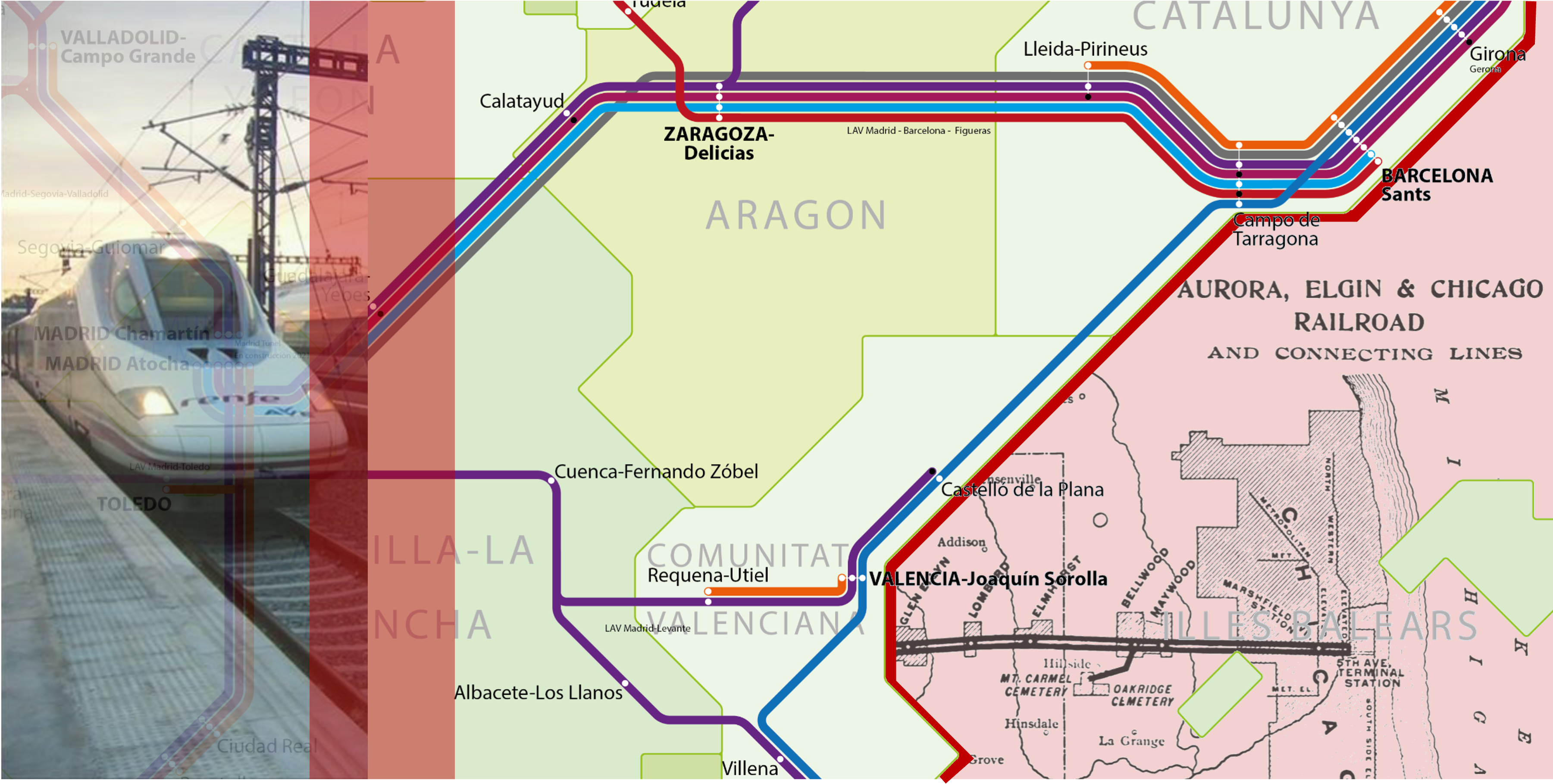
Hello Interactors,Spain’s high-speed trains feels like a totally different trajectory of modernity. America prides itself on being the tech innovator, but nowhere can we blast 180 MPH between city centers with seamless transfers to metros and buses…and no TSA drudgery. But look closer and the familiar comes into view — rising car ownership, rush-hour congestion (except in Valencia!), and growth patterns that echo America. I wanted to follow these parallel tracks back to the nineteenth-century U.S. rail boom and forward to Spain’s high-spe ed era. Turns out it’s not just about who gets faster rail or faster freeways, but what kind of growth they lock in once they arrive.TRAINS, CITIES, AND CONTRADICTIONSMy wife and I took high-speed rail (HSR) on our recent trip to Spain. My first thought was, “Why can’t we have nice things?”They’re everywhere.Madrid to Barcelona in two and a half hours. Barcelona to Valencia, Valencia back to Madrid. Later, Porto to Lisbon. Even Portugal is in on it. We glided out of city-center stations, slipped past housing blocks and industrial belts, then settled into the familiar grain of Mediterranean countryside at 300 kilometers an hour. The Wi-Fi (mostly) worked. The seats were comfortable. No annoying TSA.Where HSR did not exist or didn’t quite fit our schedule, we filled gaps with EasyJet flights. We did rent a car to seek the 100-foot waves at Nazaré, Portugal, only to be punished by the crawl of Porto’s rush-hour traffic in a downpour. Within cities, we took metros, commuter trains, trams, buses, bike share, and walked…a lot.From the perspective of a sustainable transportation advocate, we were treated to the complete “nice things” package: fast trains between cities, frequent rail and bus service inside them, and streets catering to human bodies more than SUVs. What surprised me, though, was the way these nice things coexist with growth patterns that look — in structural terms — uncomfortably familiar.In this video 👆 from our high-speed rail into Madrid, you see familiar freeway traffic but also a local rail running alongside. This site may be more common in NYC, DC, Boston, and even Chicago but less so in the Western US. Spain now operates one of the world’s largest high-speed networks. Spaniards reside inside a country roughly the size of Texas and enjoy about 4,000 kilometers of dedicated lines. This is Europe’s largest HSR system and one of only a handful of “comprehensive national networks” worldwide (Campos & de Rus, 2009; Perl & Goetz, 2015; UIC, 2024). Yet, like most of Europe, it has also seen a steady rise in car ownership. Across the EU, the average number of passenger cars per capita increased from 0.53 to 0.57 between 2011 and 2021, with Spain tracking that upward trend (Eurostat, 2023). Inland passenger-kilometers remain dominated by private cars, with rail — high-speed and conventional combined — taking a modest minority share (European Commission, 2021).Spain, in other words, has both extensive HSR and rising car ownership. The tension between the pleasant micro-geographies of rail stations, sidewalks, and metro lines and the macro-geography of an ever-familiar car-dependent growth regime makes it interesting from an economic geography standpoint. HSR in Spain is not so much an alternative to growth but a particular way of organizing it.America was once organized around rail. But our own car-dependent growth regime pushed it away. In the late nineteenth century, the United States was the HSR superpower of its time.From the 1830s through the early twentieth century, a dense mesh of rail lines shortened distances across the continent. By 1916, the U.S. rail network peaked at roughly 254,000 route miles — enough track to circle the globe multiple times. It then went into steep decline under competition from cars and trucks (Stover, 1997; The RAND Corporation, 2008). Rail was not merely a mode of transport. It was the primary infrastructure for integrating an entire continent’s economy.Chicago was the canonical beneficiary. William Cronon’s Nature’s Metropolis makes the case that rail-driven “time–space compression” did as much as natural endowments to elevate Chicago from muddy frontier town to the pivot of a continental system of grain, lumber, and meat (Cronon, 1991). Rail lines did not simply connect places that already mattered; they reorganized what mattered by funneling resources, capital, and people through specific nodes. Economic geography here is not just about location, but about which locations are made central by network design.This “time–space compression” traces back to Karl Marx’s 1857–58 Grundrisse, where he described the “annihilation of space by time” as capitalism’s drive to overcome spatial barriers through faster transport like railroads to enable quicker turnover of capital. Geographer David Harvey formalized the term “time–space compression” in his 1989 The Condition of Postmodernity, building on Marx to analyze how nineteenth-century rail
An Economic Geography of Complicity and Control
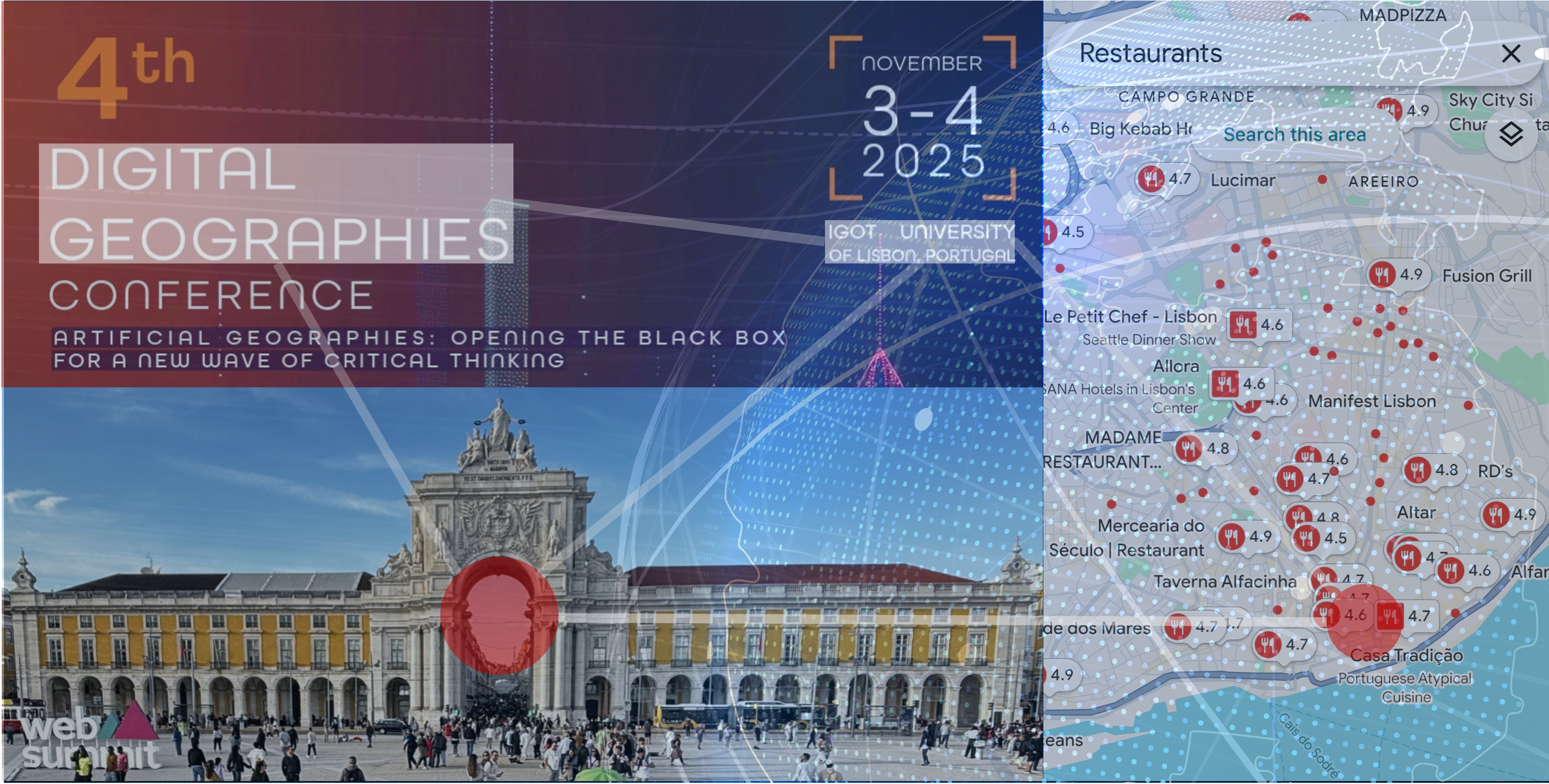
Hello Interactors,I’m back! After a bit of a hiatus traveling Southern Europe, where my wife had meetings in Northern Italy and I gave a talk in Lisbon. We visited a couple spots in Spain in between. Now it’s time to dive back into our exploration of economic geography. My time navigating those historic cities — while grappling with the apps on my phone — turned out to be the perfect, if slightly frustrating, introduction to the subject of the conference, Digital Geography.The presentation I prepared for the Lisbon conference, and which I hint at here, traces how the technical optimism of early desktop software evolved into the all-encompassing power of Platform Capital. We explore how digital systems like Airbnb and Google Maps have become more than just convenient tools. They are the primary architects of urban value. They don’t just reflect economic patterns. They mandate them. They reorganize rent extraction by dictating interactions with commerce and concentrating control. This is the new financialized city, and the uncomfortable question we must face is this: Are we leveraging these tools toward a new beneficial height, or are the tools exploiting us in ways that transcends oversight?CARTOGRAPHY’S COMPUTATIONAL CONVERGENCEI was sweating five minutes in when I realized we were headed to the wrong place. We picked up the pace, up steep grades, glissading down narrow sidewalks avoiding trolley cars and private cars inching pinched hairpins with seven point turns. I was looking at my phone with one eye and the cobbled streets with the other.Apple Maps had led us astray. But there we were, my wife and I, having emerged from the metro stop at Lisbon’s shoreline with a massive cruise ship looming over us like a misplaced high-rise. We needed to be somewhere up those notorious steep streets behind us in 10 minutes. So up we went, winding through narrow streets and passages. Lisbon is hilly. We past the clusters of tourists rolling luggage, around locals lugging groceries.I had come to present at the 4th Digital Geographies Conference, and the organizers had scheduled a walking tour of Lisbon. Yet here I was, performing the very platform-mediated tourism that the attendees came to interrogate. My own phone was likely using the same mapping API I used to book my AirBnB. These platforms were actively reshaping the Lisbon around us. The irony wasn’t lost on me. We had gathered to critically examine digital geography while simultaneously embodying its contradictions.That became even more apparent as we gathered for our walking tour. We met in a square these platform algorithms don’t push. It’s not “liked”, “starred”, nor “Instagrammed.” But it was populated nonetheless…with locals not tourists. Mostly immigrants. The virtual was met with reality.What exactly were we examining as we stood there, phones in hand, embodying the very contradictions we’d gathered to critique?Three decades ago, as an undergraduate at UC Santa Barbara, I would have understood this moment differently. The UCSB geography department was riding the crest of the GIS revolution then. Apple and Google Maps didn’t exist, and we spent our days digitizing boundaries from paper maps, overlaying data layers, building spatial databases that would make geographic information searchable, analyzable, computable. We were told we were democratizing cartography, making it a technical craft anyone could master with the right tools.But the questions that haunt me now — who decides what gets mapped? whose reality does the map represent? what work does the map do in the world? — remained largely unasked in those heady days of digital optimism.Digital geography, or ‘computer cartography’ as we understood it then, was about bringing computational precision to spatial problems. We were building tools that would move maps from the drafting tables of trained cartographers to the screens of any researcher with data to visualize. Marveling at what technology might do for us has a way of stunting the urge to question what it might be doing to us.The field of digital geography has since undergone a transformation. It’s one that mirrors my own trajectory from building tools and platforms at Microsoft to interrogating their societal effects. Today’s digital geography emerges from the collision of two geography traditions: the quantitative, GIS-focused approach I learned at UCSB, and critical human geography’s interrogation of power, representation, and spatial justice. This convergence became necessary as digital technologies escaped the desktop and embedded themselves in everyday urban life. We no longer simply make digital maps of cities and countrysides. Digital platforms are actively remaking cities themselves…and those who live in them.Contemporary digital geography, as examined at this conference, looks at how computational systems reorganize spatial relations, urban governance, and the production of place itself. When Airbnb’s algorithm determines neighborhood prop
Spirals of Enclosure
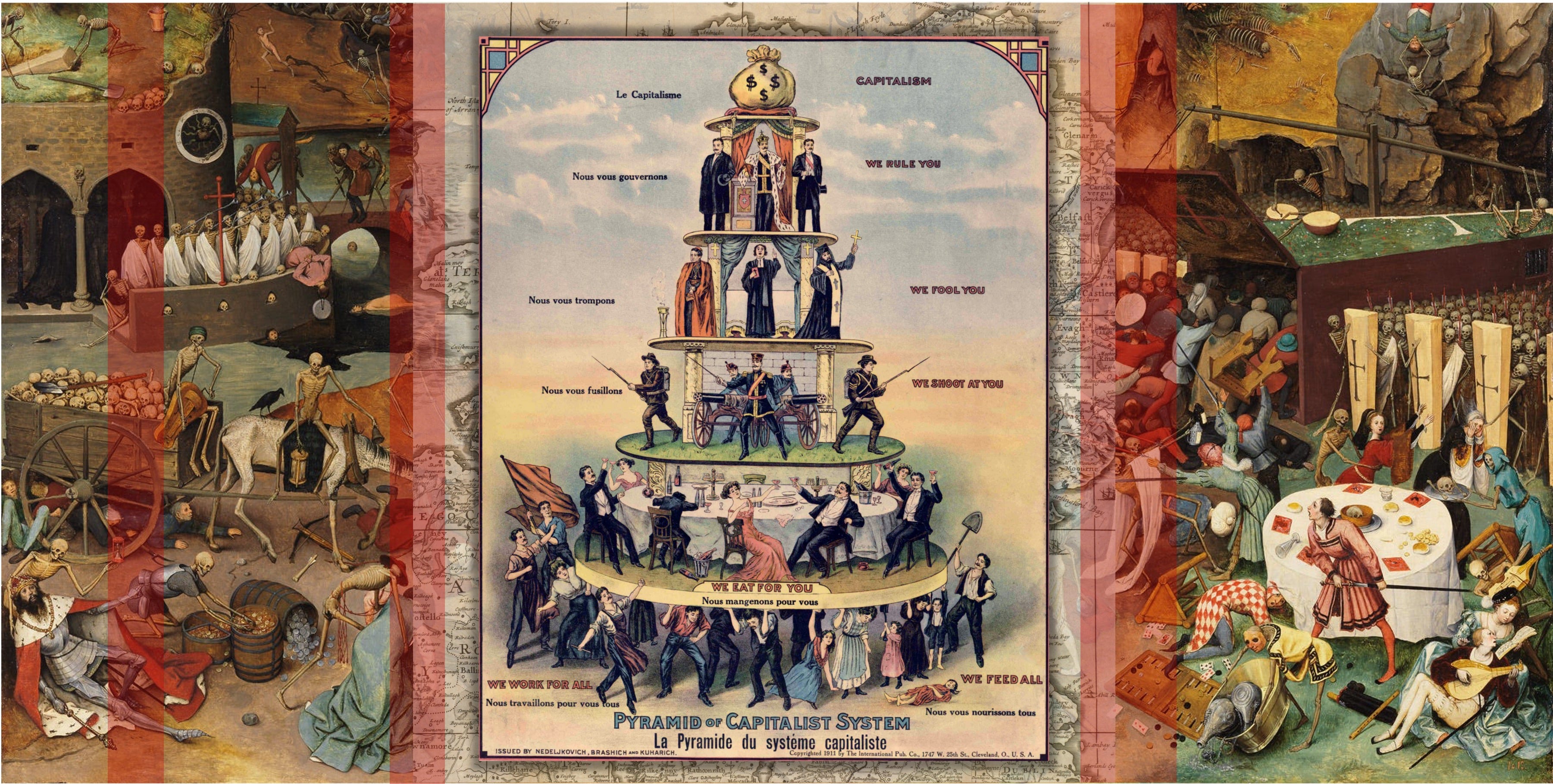
Hello Interactors,Fall is in full swing here in the northern hemisphere, which means it’s time to turn our attention to economics and economic geography. Triggered by a recent podcast on the origins of capitalism, I thought I’d kick off by exploring this from a geography perspective.I trace how violence, dispossession, and racial hierarchy aren’t simple externalities or accidents. They emerge out of a system that organized itself and then spread. Capitalism grew out of dispossession of land and human autonomy and became a dominant social and economic structure. It’s rooted in violence that became virtuous and centuries later is locked-in. Or is it?EMERGING ENGLISH ENCLOSURESThe dominant and particular brand of capitalism in force today originates in England. Before English landlords and the state violently seized common lands back in the 1300s, economic life was embedded in what historian E.P. Thompson called “moral economies”.(1) These were systems of survival where collective responsibility was managed through custom, obligation, and shared access to resources. Similar systems existed elsewhere. Long before Europeans arrived at the shores of what is now called North America, Haudenosaunee longhouse economies were sophisticatedly organized around economies of reciprocity. Further south, Andean ayllu communities negotiated labor obligations and access to land was shared. West African systems featured land that belonged to communities and ancestors, not individuals.Back in medieval English villages, commons weren’t charity, they were infrastructure. Anyone could graze animals or gather firewood. When harvests failed, there were fallbacks like hunting and gathering rights, seasonal labor sharing, and kin networks. As anthropologist Stephen Gudeman shows, these practices reflected cultures of mutual insurance aimed at collective resilience, not individual accumulation.(2)Then landlords, backed by state violence, destroyed this system to enrich themselves.From 1348-1349, the bubonic plague killed perhaps half of England’s population. This created a labor shortage that gave surviving so-called peasants leverage. For the first time they could demand higher wages, refuse exploitative landlords, or move to find better conditions.The elite mobilized state violence to reverse this. In 1351 the state passed The Statute of Labourers — an attempt to freeze wages and restrict worker movement. This serves as an early signal that reverberates today. When property and people come in conflict, the state sides with property. Over the next two centuries, landlords steadily enclosed common lands, claiming shared space as private property. Peasants who resisted were evicted, sometimes killed.Initial conditions mattered enormously. England had a relatively weak monarchy that couldn’t check landlord aggression like stronger European states did. It also had growing urban markets creating demand for food and wool and post-plague labor dynamics that made controlling land more profitable than extracting rents from secure peasants.As historian J.M. Neeson details, enclosure — fencing in private land — destroyed social infrastructure.(3) When access to common resources disappeared, so did the safety nets that enabled survival outside of market and labor competition. People simply lost the ability to graze a cow, gather fuel, glean grain, or even rely on neighbors’ obligation to help.This created a feedback loop:Each turn made the pattern stronger. Understanding how this happens requires grasping how these complex systems shaped the very people who reproduced them.The landlords driving enclosure weren’t simply greedy villains. Their sense of self, their understanding of what was right and proper, was constituted through relationships to other people like them, to their own opportunities, and to authorities who validated their actions. A landlord enclosing commons likely experienced this as “improvement”. They believed they were making the land productive while exercising newly issued property rights. Other landlords were doing it, parliament legalized it, and the economics of the time justified it. The very capacity to see alternatives was constrained by relational personal and social positions within an emerging capitalistic society.This doesn’t excuse the violence or diminish responsibility. But it does reveal how systems reproduce themselves. This happens not primarily through individual evil but through relationships and feedback loops that constitute people’s identities and sense of what’s possible. The moral judgment remains stark. These were choices that enriched someone by destroying someone else’s means of survival. But the choices were made by people whose very selfhood was being constructed by the system they were creating.Similarly, displaced peasants resisted in ways their social positions made possible. They rioted, appealed to historical customary rights, attempted to maintain the commons they relied on for centuries. Each
Masters of Mess Making and Meaning
Hello Interactors,My wife and I recently started watching the mini-series 100 Foot Wave, which follows extreme surfer Garrett McNamara’s quest to ride the mythical 100-foot breaker. The show has put Nazaré, Portugal on the map — not just as a place, but as a symbol of human daring against forces far larger than ourselves.At the same time, I’ve been listening to physicist-philosopher Sean Carroll’s recent “solo” podcast on the emergence of complexity, tracing how the universe began in simplicity and blossomed into stars, life, and consciousness. These two threads — towering waves and cosmic arcs — collided in my mind, stirring something that has been swelling in me for years: how to reconcile wonder at life’s improbable flourishing with despair at its accelerated unraveling on Earth.Should despair be the only response? Or is it possible, like the surfers at Nazaré, to recognize the peril without surrendering to it — to ride, however briefly, the wave that could also destroy us?THE COSMIC WAVEBeneath the lighthouse bluff at Nazaré, Portugal opens a canyon 140 miles long and three miles deep — three times deeper than the Grand Canyon. Born of tectonic fractures and sculpted over millions of years, it is less a static feature than a force in its own right: a conduit that gathers the ocean’s momentum and hurls it shoreward. Swells that elsewhere would pass unnoticed are here magnified into walls of water, indifferent to whether they become playground or grave. Geography conspires — wind, current, and rock — but the canyon itself is an accomplice, a reminder that Earth is never merely stage but actor. For today’s surfers, this is possibility. For centuries of fishermen, it was peril. The waves have not changed, but the stance we take toward them has — and that, too, becomes part of the story the canyon tells.So it is with complexity. Every wave begins simple, a long low swell born of distant winds, that crescendos into chaos at the shoreline. It swirls and curls into turbulent foam piqued in curious but dangerous beauty, only to dissolve back into undertow, bubbles, and silence. Our own cosmos follows the same rhythm, driven by the logic of entropy — the tendency of energy to spread, of order to give way to disorder. In the beginning, we know the universe was astonishingly simple and ordered: a hot, uniform plasma, almost featureless in its smoothness.Imagine the origin of life sitting at origin of a graph. It exists orderly in low entropy and low complexity. But entropy is restless. As it advanced diagonally up and to the right disorder increases in a straight line. This opens space for complexity to emerge. Early on in the cosmos tiny quantum fluctuations stretched into patterns, atoms gathered into stars, stars fused new elements as galaxies spun, coalesced, and collided. Imagine this as the complexity line on our graph. It also grows with time but takes the shape of a parabolic wave climbing upward to a smooth crest as it increases in complexity. Meanwhile, entropy ticks steadily up and to the right as a straight arrow of time forever growing in disorder as our universe continues to increase in complexity.We are now somewhere on this complexity curve. And this is the paradox of our middle epoch. Entropy never reverses course — disorder always increases — yet along that trajectory the complexity within we live crests, like a wave gathering its final height. For a sliver of cosmic time, the universe has been rich, complex, and with structure. On at least one world in the cosmos, life emerges and even creates complex organisms like us. But if entropy pushes inexorably forward, complexity will not hold indefinitely. Stars will exhaust their fuel, galaxies will drift into darkness, and matter itself may decay. This diagram reminds us that complexity rises only to fall again, tracing an arc back toward simplicity even as entropy continues its steady climb.In this framing, the universe is not a march from order to chaos but a cycle of simple-to-complex-to-simple played out against entropy’s one-way slope. We live in a fleeting middle where complexity momentarily flourishes. Like the wave at Nazaré, born as a long low swell, steepening into a towering wall of water, then dissolving again into foam, undertow, and silence, our cosmos crests only once. The question is not whether entropy wins — it does — but how we dwell, and what we make of meaning, within the brief surge of complexity it permits.It took a lot to get us to this point. This complex space that entropy has carved within cosmic time leaves room for novelty. Complexity flourishes locally even as disorder deepens globally. Out of this novel initial imbalance, life emerged — fragile metabolisms harvesting energy from their surroundings, weaving temporary order against the grain of entropy. From single-celled organisms to multicellular bodies, from photosynthesis to predation, biology layered new strategies of survival atop older ones. Evolution diversified li
Native or Not? How Science, Politics, and Physics Decide Who Belongs
Hello Interactors,It’s been awhile as I’ve been enjoying summer — including getting in my kayak to paddle over to a park to water plants. Time on the water also gets me thinking. Lately, it’s been about what belongs here, what doesn’t, and who decides? This week’s essay follows my trail of thought from ivy-covered fences to international borders. I trace how science, politics, and even physics shape our ideas of what’s “native” and what’s “invasive.”INVASION, IVY, AND ICEAs I was contemplating this essay in my car at a stop light, a fireweed seedling floated through the sunroof. Fireweed is considered “native” by the U.S. Government, but when researching this opportunistic plant — which thrives in disturbed areas (hence it’s name) — I learned it can be found across the entire Northern Hemisphere. It’s “native” to Japan, China, Korea, Siberia, Mongolia, Russia, and all of Northern Europe. Because its primary dispersal is through the wind, it’s impossible to know where exactly it originated and when. And unlike humans, it doesn’t have to worry about borders.So long as a species arrives on its own accord through wind, wings, currents, or chance — without a human hand guiding it — it’s often granted the status of “native.” Never mind whether the journey took decades or millennia, or if the ecosystem has since changed. What matters is that it got there on its own, as if nature somehow stamped its passport.As long time Interactors may recall, I spend the summer helping water “native” baby plants into maturity in a local public green space. A bordering homeowner had planted an “invasive species”, English Ivy, years ago and it climbed the fence engulfing the Sword Ferns, Vine Maples, and towering Douglas Fir trees common in Pacific Northwest woodlands. A nearby concerned environmentalist volunteered to remove the “alien” ivy and plant “native” species through a city program called Green Kirkland. Some of the first Firs he planted are now taller than he is! Meanwhile, on the ground you see remnants of English Ivy still trying to muster a comeback. The stuff is tenacious.This is also the time of year in the Seattle area when Himalayan Black Berries are ripening. These sprawls of arching spikey vines are as pernicious as they are delicious. Nativist defenders try squelching these invaders too. But unlike English Ivy, these “aliens” come with a sugary prize. You’ll see people walking along the side of roads with buckets and step stools trying their darnedest to pluck a plump prize — taking care not to get poked or pierced by their prickly spurs.This framing of “invasive” versus “native” has given me pause like never before, especially as I witness armed, masked raids on homes and businesses carried out by U.S. Immigration and Customs Enforcement (ICE) agents. These government officials, who are also concerned and deeply committed citizens, see themselves as removing what they label “invasive aliens” — individuals they fear might overwhelm the so-called “native” population. As part of the Department of Homeland Security, they work to secure the “Homeland” from what is perceived as an invasion by unwanted human movement. In reflecting on this, I ask myself: how different am I from an ICE agent when I labor to eradicate plants I have been taught to call “invasive” while nurturing so-called “native” species back to health? Both of us are acting within a worldview that categorizes beings as either threats or treasures. At what cost, and with what consequences?According to a couple other U.S. agencies (like the National Park Service and the U.S. Department of Agriculture) species are considered native if they were present before European colonization (i.e., pre-1492). The idea that a species is “native” if it was present before 1492 obviously reflects less a scientific ecological reality than a political opinion of convenience. Framing nativity through the lens of settler history rather than ecological process ignores not only millennia of Indigenous land stewardship, but prehistoric human introductions and natural migrations shaped by climate and geology. Trying pin down what is “native” is like picking up a squirming earthworm.These little critters, which have profoundly altered soil ecosystems in postglacial North America, are often labeled “naturalized” rather than “native” because their arrival followed European colonization. Yet this classification ignores the fact that northern North America had no earthworms at all for thousands of years after the glaciers retreated. There were scraped away with the topsoil. What native species may exist in North America are confined to the unglaciated South.What’s disturbing isn’t just the worms’ historical presence but the simplistic persistent narrative that ecosystems were somehow stable until 1492. How is it possible that so many people still insist it was colonial contact that supposedly flipped some ecological switch? In truth, landscapes have always been in motion. They’ve be
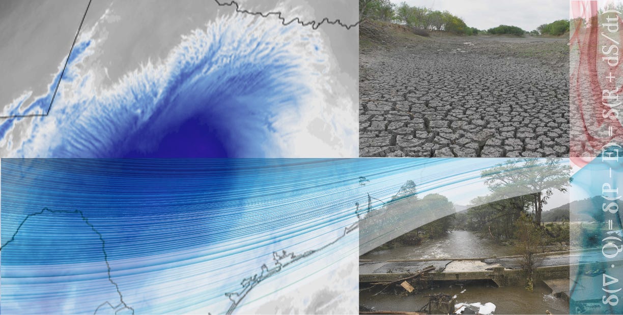
When the Sky Swells, the Land Breaks
Hello Interactors,It’s hard to ignore the situation in Texas, especially as I turn my attention to physical geography. 'Flash Flood Alley', as it’s called by hydrologists, had already been pounded by days of relentless rain, soaking the soil and swelling the rivers. It left the region teetering on the edge of catastrophe. Then came the deluge. A torrent so sudden and intense it dumped a month’s worth of rain in under an hour. Roads turned to rivers. Homes were lost. Lives were too. As the floodwaters recede, what remains isn’t just devastation — it’s a lesson. One about a changing water cycle, a shifting climate, and a stubborn way of thinking that still dominates how we plan for both.DROUGHT AND DELUGEIs Texas drowning due to climate change? Just three years ago, we were told it’s drying up. That’s when a record drought emptied reservoirs and threw aquifers into steep decline. From 2011 to 2015, 90% of the state was in extreme drought. This seesaw between soaked and scorched is the kind of muddled messaging that lets climate deniers laugh all the way to the comment section.The truth is Texas is drying up AND drowning. This paradox isn’t just Texas-sized — it’s systemic. Our habit of translating global climate shifts into local weather soundbites is failing us.According to hydrologist Benjamin Zaitchik and colleagues, writing in Nature Water in 2023, two dominant narratives frame how these events are explained. Public and policy reporting on patterns like those in Texas usually falls into two camps:* The "Wet-Get-Wetter, Dry-Get-Drier" (WWDD) hypothesis — climate change intensifies existing hydrological patterns, bringing more rain to wet regions and more drought to dry ones.* The "Global Aridification" (GA) hypothesis — warming increases the atmosphere's "thirst," drying out land even where rainfall remains steady.Both frameworks can explain real conditions, but the recent Texas floods expose their limits. If a region long seen as drying can also produce one of the most intense floods in U.S. history, are these ideas flawed — or just too rigidly applied?WWDD and GA aren’t competing truths. They’re partial heuristics for a nonlinear, complex water system. Yet our brains favor recent events, confirm existing beliefs, and crave simple answers. So we latch onto one model or the other. But these simplified labels often ignore scale, context, and the right metrics. Is a region drying or wetting based on annual rainfall? Soil moisture? Streamflow? Urbanization? Atmospheric demand?Texas — with its sprawling cities, irrigated farms, and dramatic east–west gradient in rainfall and vegetation — resists binary climate narratives. One year it exemplifies GA, with depleted aquifers and parched soil. The next, like now, it fits WWDD, as Tropical Storm Barry — arriving after days of relentless rainfall — stalled over saturated land, unleashing a torrent so fierce it overwhelmed the landscape.Zaitchik and his team call for a clarification approach. Instead of umbrella labels, we should specify which variables and timeframes are shifting. A place can be parched, pummeled, and primed to flood — sometimes all in the same season. And those shifting moods in the water set the stage for something deeper — a mathematical reckoning.MATH MEETS MAYHEMThis debate boils down to three basic equations — one for the land, one for the sky, and one for how the system changes over time. But that means prying open the black box of math symbols still treated like sacred script by academics and STEM pros.Let’s be clear, these equations aren’t spells. They’re just shorthand — like a recipe or a flowchart. The symbols may look like hieroglyphs, but they describe familiar things. Precipitation falls (P). Water evaporates or gets sucked up by plants — evapotranspiration (E). Some runs off (R). Some sinks in (S). Time (t) tells us when it’s happening. The 'd' in dS and dt just means "change in" — how much storage (S) increases or decreases over time (t). The Greek letters — ∇ (nabla) and δ (delta) — simply mean change, across space and time. If you can track a bank account, you can follow these equations. And if you’ve ever watched a lawn flood after a storm, you’ve seen them in action.You don’t need a PhD to understand water, just a willingness to see through the symbols.* LAND: The Water Balance EquationP − E = R + dS/dtPrecipitation (P) minus evapotranspiration (E) equals runoff (R) plus the change in stored water (dS/dt).* SKY: The Vapor Flux EquationP − E = ∇ ∙ QThis links land and atmosphere. ∇ (nabla) tracks change across space, and Q is vapor flux — the amount of moisture moving through the atmosphere from one place to another, carried by winds and shaped by pressure systems. The dot product (∙) measures how much of that vapor is moving into or out of an area. So ∇ ∙ Q shows whether moist air is converging (piling up to cause rain) or diverging (pulling apart and drying).* SYSTEM: The Change Equationδ(∇ ∙ Q) = δ(P − E) = δ(R + dS/dt)This sh
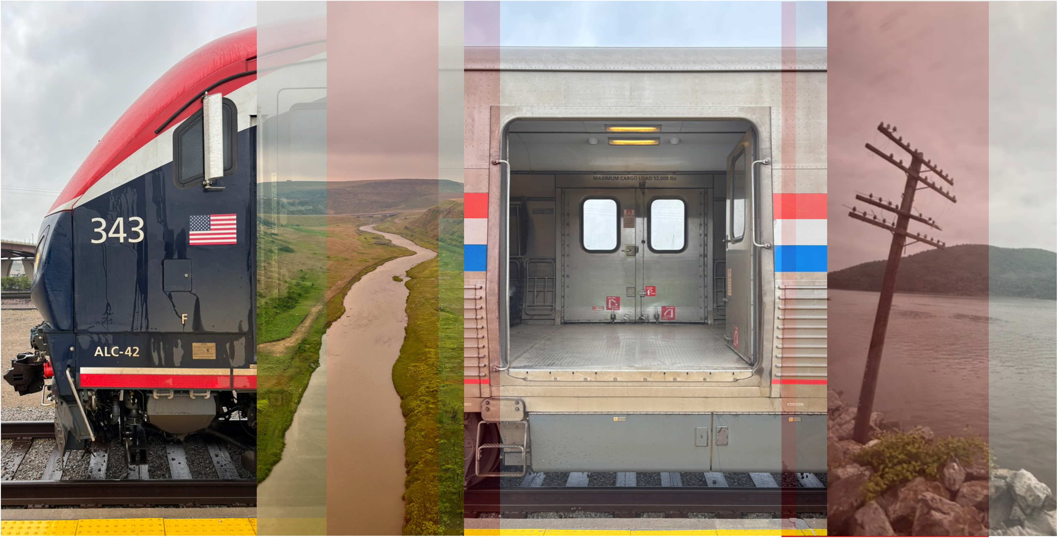
Red, White, and Choo Choo
Hello Interactors,Happy Fourth of July and welcome to a brand new season of Interplace! We’re kicking things off with a video of my cross-country rail trip that took about four days to ride…and nearly twice as long to edit and produce. This first ever Interplace video launches our summer focus on physical geography and the environment. I hope you enjoy a slow journey through space, place, and the unexpected beauty between the coasts. This is a public episode. If you would like to discuss this with other subscribers or get access to bonus episodes, visit interplace.io

How Cities Loop Us In
Hello Interactors,My daughter in Manhattan’s East Village sent me an article about the curated lives of the “West Village girls.” A few days later, I came across a provocative student op-ed from the University of Washington: "Why the hell do we still go to Starbucks?" The parallels stood out.In Manhattan’s West Village, a spring weekend unfolds with young women jogging past a pastry shop in matching leggings, iced matcha lattes in hand. Some film it just long enough for TikTok. Across the country, students cycle through Starbucks in Seattle’s U-District like clockwork. The drinks are overpriced and underwhelming, but that’s not the point. It’s familiar. It's part of a habitual loop.Different cities, similar rhythms. One loop is visual, the other habitual. But both show how space and emotion sync. Like an ambient synth track, they layer, drift, and return. If you live in or near a city, you exist in your own looping layers of emotional geography.FLASH FEEDSMy daughter has been deep into modular synthesis lately — both making and listening. It’s not just the music that intrigues her, but the way it builds: loops that don’t simply repeat, but evolve, bend, and respond. She’ll spend hours patching sounds together, adjusting timing and tone until something new emerges. She likens it to painting with sound. Watching her work, it struck me how much her synth music mirrors city life — not in harmony, but in layers. She’s helped me hear urban rhythms differently.Like a pop synth hook, the Flash loop is built for attention. It's bright, polished, and impossible to ignore. Synth pop thrives on these quick pulses — hooks that grab you within seconds, loops that deliver dopamine with precision. Urban spaces under this loop do the same. They set a beat others fall in line with, often flattening nuance in exchange for momentum.This isn’t just about moving to a beat. It’s about becoming part of the beat. When these fast loops dominate, people start adapting to the spaces that reflect them. And those spaces, in turn, evolve based on those very behaviors. It’s a feedback loop: movement shaping meaning, and meaning shaping movement. The people become both the input and the output.In this context, the West Village girl isn’t just a person — she’s a spatial feedback loop. A mashup of Carrie Bradshaw nostalgia, Instagram polish, and soft-lit storefronts optimized for selfies. But she didn’t arrive from nowhere. She emerged through a kind of spatial modeling: small choices, like where to brunch, where to pose, where to post are repeated so often they remade a neighborhood.Social psychologist Erving Goffman, writing in the 1950s, called this kind of self-presentation "impression management." He argued that much of everyday life is performance. Not in the theatrical sense, but in how we act in response to what we expect others see. Urban spaces, especially commercial ones, are often the stage. But today, that performance isn’t just for others in the room. It’s for followers, algorithms, and endless feeds. The “audience” is ambient, but its expectations are precise.As places like the West Village get filtered through lifestyle accounts and recommendation algorithms, their role changes. They no longer just host people, but mirror back a version of identity their occupants expect to see. Sidewalks become catwalks. Coffee shops become backdrops. Apartment windows become curated messes of string lights and tasteful clutter. And increasingly, the distinction between what’s lived and what’s posted collapses.This fast loop — what we might call spatial virality — doesn’t just show us how to act in a place. It scripts the place itself. Stores open where the foot traffic is photogenic. Benches are placed for backdrops, not rest. Even the offerings shift: Aperol spritzes, charm bars, negroni specials sold not for taste but for tagability.These are the high-tempo loops. They grab attention and crowd the mix. But every modular synth set, like a painting, needs contrast.So some people opt out, or imagine doing so. Not necessarily with loud protest, but quiet rejection. They look for something slower. Something that isn’t already trending...unless the trend of routine sucks you in.PULSING PATTERNSIf Flash is the pop hook, Pulse is the counter-melody. It could be a bassline or harmony that brings emotional weight and keeps things grounded. In music, you may not always notice it, but you'd miss it if it were gone. In cities, this loop shows up in slow friendships, mutual aid, and cafés that begin to feel like second homes. These are places where regulars greet one another by name. Where where hours melt through conversations. It satisfies a need to be seen, but without needing to perform. It’s what holds meaning when spectacle fades.If the fast loop turns space into spectacle, the counter loop tries to slow it down. It lures the space to feel lived in, not just liked. It’s not always radical. Sometimes it’s just choosing a different coffee shop.Back
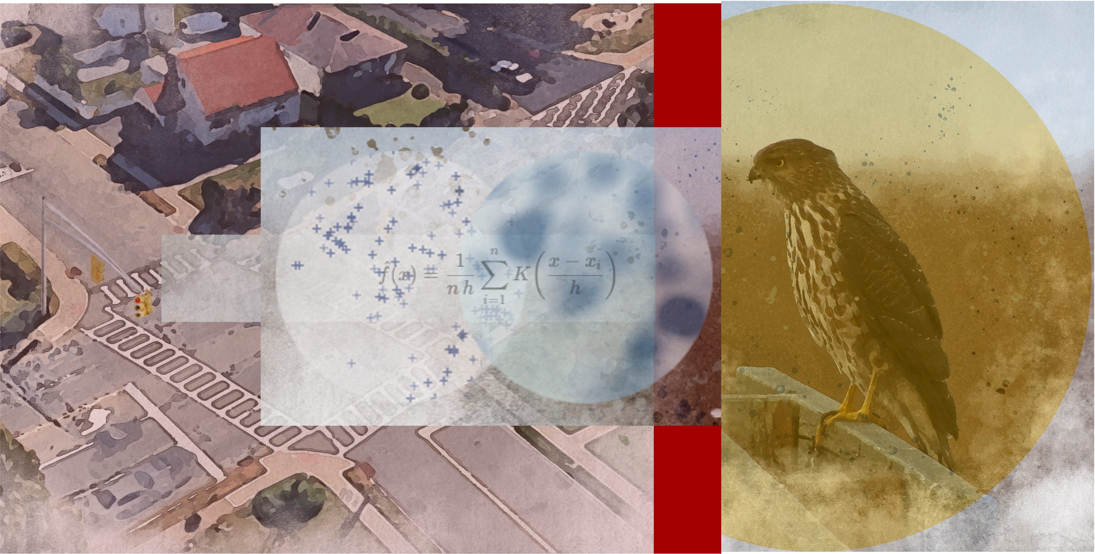
Beaks, Brakes, and Brainwaves
Hello Interactors, This week, four strange bird encounters landed in my lap — three in real life, one on my screen. First, a crow tore through the bushes in our yard chasing a frantic nuthatch. Moments later, I spotted two more crows feasting on roadkill just outside our house. Then, while walking with my wife, we watched four ducks in hot pursuit of another, flapping furiously down the street — some kind of aerial turf war. And finally, scrolling through my feed, I stumbled on a paper describing a Cooper’s Hawk hacking the city’s traffic system to hunt smarter. After all that, I tried seeing cities as a bird might. So I wrote as one.HISS, HUM, HUNTI first sense the city as vibration. Before sun rays even breech the branches, a hiss of car tires emerge; street lamps click off; somewhere a garage door rumbles open. Each resonance strikes the hollow chambers of my bones like sonar. It’s a sketch of distance, density, and direction. This all makes perfect sense to me even though I am just a kid. A juvenile Cooper’s Hawk — Accipiter cooperii — yet the human-made maze below me is as legible to me as the nest I left barely two winters ago. What follows, in human words, is a recount of one day’s hunt. I hope to demonstrate what humans regard as intelligence, innovation, and enterprise exists in a single act of predation.DANCING WITH DATA AT DAWNPerched on a gray mast of the Main and Prospect traffic light, I begin to render the scene. My basemap is no pixel grid glowing on some screen across town; it is a topological organ in my scull. Topology matters when a lamppost sits one maneuver away from the porch roof, which is one glide away from the dumpster rim. My so-called ‘bird brain’ calculates dynamic flows of probability. One flip of a traffic light, a garbage truck rolls by, and that gust of wind changes direction. My internal map pulses between “larger” when prey likelihood rises and “smaller” when likelihood falls.As I gaze out above the east-west avenue, a slipstream peels off the 7AM wave of commuters. I spot a sparrow in a vortex that spirals from the garbage truck’s wake at 07∶13. That acoustic shadow beneath that florist’s van is one place I could pass unseen. But is a sparrow worth it?What I am doing — unknown even to myself — is what spatial scientists call real‑time kernel‑density estimation. At any point on a simple 2D path I can plop a small mathematical bump — a kernel. I can then reason about the density mapped below me by stacking up every bump’s contribution at a particular spot. That once scatter of points on a map morphs into a smooth curve that shows where meaningful observations truly cluster. I continuously weight a landscape of pigeons, cyclists, and idling SUVs by situational context rather than simple Euclidean distance.Complexity geographer David O’Sullivan calls this kind of adaptive map a narrative model — a story the system tells itself so it can keep acting. My mental basemap obeys what is adjacent to what on this map. After all, a three‑meter hedge is more impenetrable than thirty meters of empty air; therefore straight‑line distances can lie and deceive. When humans try to simplify distances by saying, ‘as the crow flies’, they have no idea what they’re leaving out.BRAKES BUILD BARRICADESAt 07∶26 a stainless‑steel button is pressed; I hear the relay’s metallic click 3.2 seconds before the little white pedestrian blinks alive. I am perched here because I anticipated this poke by pedestrians on their morning commute. Vehicles will now queue as these bi-peds spill into the cross walk. The stacked metal boxes of steel, rubber, and plastic will form a barricade forty meters long…potentially.Brake‑lights align into a pulsing crimson corridor whose half‑life I have calculated and averaged across nineteen previous dawns. Humans call the coming congestion a nuisance, but I call it camouflage. For twenty‑two seconds the asphalt canyon’s turbulence drops below an acceptable range. I can now hover as if among cedars.A scientist has been watching from the opposite curb. They will soon begin recording this trick in their field book as so: a hawk anticipates the signal pattern and times its dives to the red‑phase distribution of brake lights.Because most queues are short, but occasionally very long, I have to be careful to time this properly. If I dive for prey based on the overall mean of the lineup, I will arrive while half the cars were still rolling to a stop — dangerous. So instead, I consider just the top-10% longest lines. Scientists marvel that I learned this algorithm in a single winter. I marvel that they need calculators to compute it.ZEBRA STRIPE SLALOM STRIKEI drop. The scent of hot rubber folds swirls with the cedar‑resin on my breast feathers as the warm air fills my plumage. The slowing bumper of a school bus becomes a landing spot — a moving parapet. Fresh into the dive, the thermoplastic zebra stripes flash white‑white‑white like a stroboscopic speedometer. None of this was made
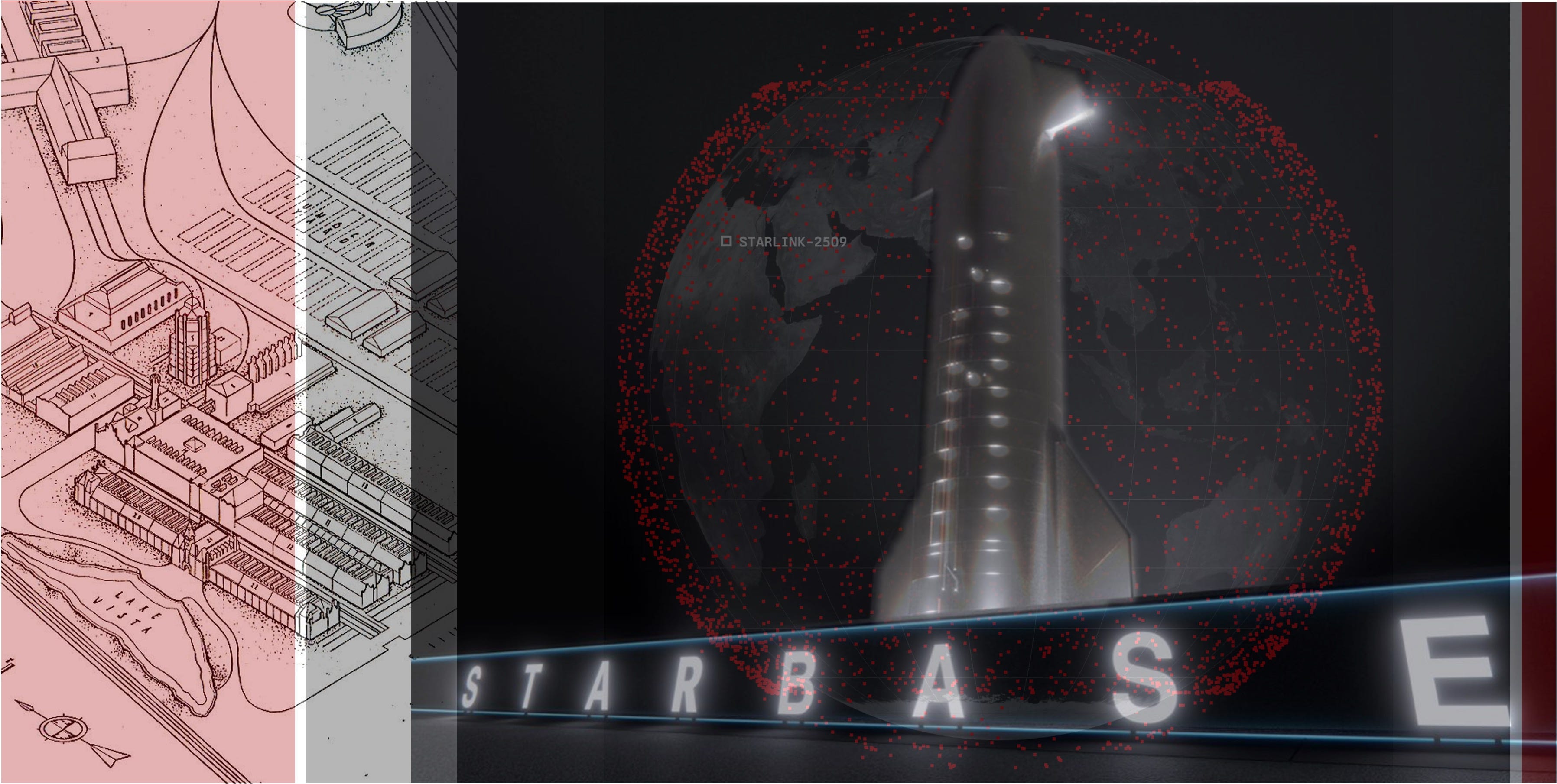
Launchpads, Land Grabs, and Loopholes
Hello Interactors,I was in Santa Barbara recently having dinner on a friend’s deck when a rocket’s contrail streaked the sky. “Another one from Vandenberg,” he said. “Wait a couple minutes — you’ll hear it.” And we did. “They’ve gotten really annoying,” he added. He’s not wrong. In early 2024, SpaceX launched seven times more tonnage into space than the rest of the world combined, much of it from Vandenberg Space Force Base (renamed from Air Force Base in 2021). They’ve already been approved to fly 12,000 Starlink satellites, with filings for 30,000 more.This isn’t just future space junk — it’s infrastructure. And it’s not just in orbit. What Musk is doing in the sky is tied to what he’s building on the ground. Not in Vandenberg, where regulation still exists, but in Starbase, Texas, where the law doesn’t resist — it assists. There, Musk is testing how much sovereignty one man can claim under the banner of “innovation” — and how little we’ll do to stop him.TOWNS TO THRUST AND THRONEMusk isn’t just defying gravity — he’s defying law. In South Texas, a place called Starbase has taken shape along the Gulf Coast, hugging the edge of SpaceX’s rocket launch site. What looks like a town is really something else: a launchpad not just for spacecraft, but for a new form of privatized sovereignty.VIDEO: Time compresses at the edge of Starbase: a slow-built frontier where launch infrastructure rises faster than oversight. Source: Google EarthThis isn’t unprecedented. The United States has a long lineage of company towns — places where corporations controlled land, housing, labor, and local government. Pullman, Illinois is the most famous. But while labor historians and economic geographers have documented their economic and social impact, few have examined them as legal structures of power.That’s the gap legal scholar Brian Highsmith identifies in Governing the Company Town. That omission matters — because these places aren’t just undemocratic. They often function as quasi-sovereign legal shells, designed to serve capital, not people.Incorporation is the trick. In Texas, any area with at least 201 residents can petition to become a general-law municipality. That’s exactly what Musk has done. In a recent vote (212 to 6) residents approved the creation of an official town — Starbase. Most of those residents are SpaceX employees living on company-owned land…with a Tesla in the driveway. The result is a legally recognized town, politically constructed. SpaceX controls the housing, the workforce, and now, the electorate. Even the mayor is a SpaceX affiliate. With zoning powers and taxing authority, Musk now holds tools usually reserved for public governments — and he’s using them to build for rockets, not residents…unless they’re employees.VIDEO: Starbase expands frame by frame, not just as a company town, but as a legal experiment — where land, labor, and law are reassembled to serve orbit over ordinance. Source: Google EarthQuinn Slobodian, a historian of neoliberalism and global capitalism, shows how powerful companies and individuals increasingly use legal tools to redesign borders and jurisdictions to their advantage. In his book, Cracked Up Capitalism, he shows how jurisdiction becomes the secret weapon of the capitalist state around the world. I wrote about a techno-optimist fantasy state on the island of Roatán, part of the Bay Islands in Honduras a couple years ago. It isn’t new. Disney used the same playbook in 1967 with Florida’s Reedy Creek District — deeding slivers of land to employees to meet incorporation rules, then governing without real opposition. Highsmith draws a straight line to Musk: both use municipal law not to serve the public, but to avoid it. In Texas, beach access is often blocked near Starbase — even when rockets aren’t launching. A proposed bill would make ignoring an evacuation order a Class B misdemeanor, punishable by jail.Even if Starbase never fully resembles a traditional town, that’s beside the point. What Musk is really revealing isn’t some urban design oasis but how municipal frameworks can still be weaponized for private control. Through zoning laws, incorporation statutes, and infrastructure deals, corporations can shape legal entities that resemble cities but function more like logistical regimes.And yet, this tactic draws little sustained scrutiny. As Highsmith reminds us, legal scholarship has largely ignored how municipal tools are deployed to consolidate corporate power. That silence matters — because what looks like a sleepy launch site in Texas may be something much larger: a new form of rule disguised as infrastructure.ABOVE THE LAW, BELOW THE LANDElon Musk isn’t just shaping towns — he’s engineering systems. His tunnels, satellites, and rockets stretch across and beyond traditional borders. These aren’t just feats of engineering. They’re tools of control designed to bypass civic oversight and relocate governance into private hands. He doesn’t need to overthrow the state to
Cities in Chaos, Connection in Crisis
Hello Interactors,This week, I’ve been reflecting on the themes of my last few essays — along with a pile of research that’s been oddly in sync. Transit planning. Neuroscience. Happiness studies. Complexity theory. Strange mix, but it keeps pointing to the same thing: cities aren’t just struggling with transportation or housing. They’re struggling with connection. With meaning. With the simple question: what kind of happiness should a city make possible? And why don’t we ask that more often?STRANGERS SHUNNED, SYSTEMS SIMULATEDThe urban century was supposed to bring us together. Denser cities, faster mobility, more connected lives — these were the promises of global urbanization. Yet in the shadow of those promises, a different kind of city has emerged in America with growing undertones elsewhere: one that increasingly seeks to eliminate the stranger, bypass friction, and privatize interaction.Whether through algorithmically optimized ride-sharing, private tunnels built to evade street life, or digital maps simulating place without presence for autonomous vehicles, a growing set of design logics work to render other people — especially unknown others — invisible, irrelevant, or avoidable.I admit, I too can get seduced by this comfort, technology, and efficiency. But cities aren’t just systems of movement — they’re systems of meaning. Space is never neutral; it’s shaped by power and shapes behavior in return. This isn’t new. Ancient cities like Teotihuacan (tay-oh-tee-wah-KAHN) in central Mexico, once one of the largest cities in the world, aligned their streets and pyramids with the stars. Chang’an (chahng-AHN), the capital of Tang Dynasty China, used strict cardinal grids and walled compounds to reflect Confucian ideals of order and hierarchy. And Uruk (OO-rook), in ancient Mesopotamia, organized civic life around temple complexes that stood at the spiritual and administrative heart of the city.These weren’t just settlements — they were spatial arguments about how people should live together, and who should lead. Even Middle Eastern souks and hammams were more than markets or baths; they were civic infrastructure. Whether through temples or bus stops, the question is the same: What kind of social behavior is this space asking of us?Neuroscience points to answers. As Shane O’Mara argues, walking is not just transport — it’s neurocognitive infrastructure. The hippocampus, which governs memory, orientation, and mood, activates when we move through physical space. Walking among others, perceiving spontaneous interactions, and attending to environmental cues strengthens our cognitive maps and emotional regulation.This makes city oriented around ‘stranger danger’ not just unjust — but indeed dangerous. Because to eliminate friction is to undermine emergence — not only in the social sense, but in the economic and cultural ones too. Cities thrive on weak ties, on happenstance, on proximity without intention. Mark Granovetter’s landmark paper, The Strength of Weak Ties, showed that it's those looser, peripheral relationships — not our inner circles — that drive opportunity, creativity, and mobility. Karl Polanyi called it embeddedness: the idea that markets don’t float in space, they’re grounded in the social fabric around them.You see it too in scale theory — in the work of Geoffrey West and Luís Bettencourt — where the productive and innovative energy of cities scales with density, interaction, and diversity. When you flatten all that into private tunnels and algorithmic efficiency, you don’t just lose the texture — you lose the conditions for invention.As David Roberts, a climate and policy journalist known for his systems thinking and sharp urban critiques, puts it: this is “the anti-social dream of elite urbanism” — a vision where you never have to share space with anyone not like you. In conversation with him, Jarrett Walker, a transit planner and theorist who’s spent decades helping cities design equitable bus networks, also pushes back against this logic. He warns that when cities build transit around avoidance — individualized rides, privatized tunnels, algorithmic sorting — they aren’t just solving inefficiencies. They’re hollowing out the very thing that makes transit (and cities) valuable and also public: the shared experience of strangers moving together.The question isn’t just whether cities are efficient — but what kind of social beings they help us become. If we build cities to avoid each other, we shouldn’t be surprised when they crumble as we all forget how to live together.COVERAGE, CARE, AND CIVIC CALMIf you follow urban and transit planning debates long enough, you’ll hear the same argument come up again and again: Should we focus on ridership or coverage? High-frequency routes where lots of people travel, or wide access for people who live farther out — even if fewer use the service? For transit nerds, it’s a policy question. For everyone else, it’s about dignity.As Walker puts it, coverage isn
You Are Here. But Nowhere Means Anything
Hello Interactors,This week, the European Space Agency launched a satellite to "weigh" Earth's 1.5 trillion trees. It will give scientists deeper insight into forests and their role in the climate — far beyond surface readings. Pretty cool. And it's coming from Europe.Meanwhile, I learned that the U.S. Secretary of Defense — under Trump — had a makeup room installed in the Pentagon to look better on TV. Also pretty cool, I guess. And very American.The contrast was hard to miss. Even with better data, the U.S. shows little appetite for using geographic insight to actually address climate change. Information is growing. Willpower, not so much.So it was oddly clarifying to read a passage Christopher Hobson posted on Imperfect Notes from a book titled America by a French author — a travelogue of softs. Last week I offered new lenses through which to see the world, I figured I’d try this French pair on — to see America, and the world it effects, as he did.PAPER, POWER, AND PROJECTIONI still have a folded paper map of Seattle in the door of my car. It’s a remnant of a time when physical maps reflected the reality before us. You unfolded a map and it innocently offered the physical world on a page. The rest was left to you — including knowing how to fold it up again.But even then, not all maps were neutral or necessarily innocent. Sure, they crowned capitals and trimmed borders, but they could also leave things out or would make certain claims. From empire to colony, from mission to market, maps often arrived not to reflect place, but to declare control of it. Still, we trusted it…even if was an illusion.I learned how to interrogate maps in my undergraduate history of cartography class — taught by the legendary cartographer Waldo Tobler. But even with that knowledge, when I was then taught how to make maps, that interrogation was more absent. I confidently believed I was mediating truth. The lines and symbols I used pointed to substance; they signaled a thing. I traced rivers from existing base maps with a pen on vellum and trusted they existed in the world as sure as the ink on the page. I cut out shading for a choropleth map and believed it told a stable story about population, vegetation, or economics. That trust was embodied in representation — the idea that a sign meant something enduring. That we could believe what maps told us.This is the world of semiotics — the study of how signs create meaning. American philosopher Charles Sanders Peirce offered a sturdy model: a sign (like a map line) refers to an object (the river), and its meaning emerges in interpretation. Meaning, in this view, is relational — but grounded. A stop sign, a national anthem, a border — they meant something because they pointed beyond themselves, to a world we shared.But there are cracks in this seemingly sturdy model.These cracks pose this question: why do we trust signs in the first place? That trust — in maps, in categories, in data — didn’t emerge from neutrality. It was built atop agendas.Take the first U.S. census in 1790. It didn’t just count — it defined. Categories like “free white persons,” “all other free persons,” and “slaves” weren’t neutral. They were political tools, shaping who mattered and by how much. People became variables. Representation became abstraction.Or Carl Linnaeus, the 18th-century Swedish botanist who built the taxonomies we still use: genus, species, kingdom. His system claimed objectivity but was shaped by distance and empire. Linnaeus never left Sweden. He named what he hadn’t seen, classified people he’d never met — sorting humans into racial types based on colonial stereotypes. These weren’t observations. They were projections based on stereotypes gathered from travelers, missionaries, and imperial officials.Naming replaced knowing. Life was turned into labels. Biology became filing. And once abstracted, it all became governable, measurable, comparable, and, ultimately, manageable.Maps followed suit.What once lived as a symbolic invitation — a drawing of place — became a system of location. I was studying geography at a time (and place) when Geographic Information Systems (GIS) and GIScience was transforming cartography. Maps weren’t just about visual representations; they were spatial databases. Rows, columns, attributes, and calculations took the place of lines and shapes on map. Drawing what we saw turned to abstracting what could then be computed so that it could then be visualized, yes, but also managed.Chris Perkins, writing on the philosophy of mapping, argued that digital cartographies didn’t just depict the world — they constituted it. The map was no longer a surface to interpret, but a script to execute. As critical geographers Sam Hind and Alex Gekker argue, the modern “mapping impulse” isn’t about understanding space — it’s about optimizing behavior through it; in a world of GPS and vehicle automation, the map no longer describes the territory, it becomes it. Laura Roberts, writing on film