
The Maine Weather Podcast
335 episodes — Page 6 of 7
🚨 FLOOD WATCH - Maine Weather 3/16 - Morning
Your morning Maine weather update Folks, we've got a serious situation brewing today. Warm air is surging north, but it's hitting just enough cold air to create a mess. This is a classic March battle. 📍 Keywords: Maine | ME weather forecast | morning weather update | March weather | Maine weather | morning forecast
🚨 FLOOD WATCH - Maine Weather 3/16 - Morning
Your morning Maine weather update Step outside right now and you'll feel that damp 38 degrees clinging to your jacket. Spring's trying to muscle in, pushing U S One3 degrees above normal today with a high of 53. But it's bringing a storm along for the ride. 📍 Keywords: morning forecast | ME weather forecast | morning weather update | Maine weather | Maine | March weather
🚨 HIGH WIND WARNING - Maine Weather 3/15 - Evening
Your evening Maine weather update Step outside right now and you're feeling 37 degrees under gray skies. But we hit 50 today, running a solid 10 degrees warmer than normal for mid-March. 📍 Keywords: evening weather update | evening forecast | Maine | Maine weather | March weather | ME weather forecast
🚨 WINTER WEATHER ADVISORY - Maine Weather 3/15 - Midday
Good afternoon. Maine. I'm DJ Huzz. Step outside right now and you're feeling 36 degrees, not bad for late February. Overnight bottomed out at 30, but here's the good news — we're gaining 3 minutes of daylight today. Sunrise hit at 6:55 A.M. and you've got light until 6:48 P.M. Today's all about that sunshine. Mostly sunny skies statewide with highs hitting 41 degrees from Portland to Bangor. The western mountains top out at 36, while The County reaches 33. North winds at 5 to 15 miles an hour keep things brisk along the coast, but otherwise it's a quiet Sunday. Perfect day for a walk if you ask me. As the sun sets. Tonight, clouds roll in, lows drop to 34 along the south coast, 30 in central Maine. And 25 up in Bangor, the County sees 23 degrees. After 3 A.M., a slight chance of rain develops in some areas, with a light wintry mix possible in the mountains and The County. Temperature-wise. Tuesday, rain tapers to showers by mid-morning. Temperatures crash — highs only reach the mid-40s. Wednesday turns sunny and cold, struggling to reach the low 30s with overnight lows plunging to the teens. Thursday through Saturday, partly sunny skies return. Highs gradually warm from the upper 30s to the mid-40s, with a chance of rain and snow returning by Friday night. Charge your phones and top off the gas tank before Monday's storm hits. See you this evening.
🚨 WINTER WEATHER ADVISORY - Maine Weather 3/15 - Morning
Good morning. Maine. I'm DJ Huzz. Step outside right now and it feels fairly decent, we're sitting at 35 degrees under a clear sky. That's right around where we should be for mid-March. Highs today will range from 33 degrees up in The County to 41 degrees down near Portland. You'll see plenty of sunshine, though winds will pick up a bit this afternoon, gusting to 20 miles an hour in spots. As the sun sets. Tonight, clouds thicken up ahead of our next system, while lows drop into the 20s and low 30s. Monday morning brings a mixed bag of precipitation. A Winter Weather Advisory is in effect for the mountains and northern regions from 4 A.M. To noon. You could see a light glaze of ice and up to an inch of snow before everything changes over to rain by midday. Down along the coast and in southern Maine, you're mostly looking at rain. It arrives by the Monday morning commute and becomes heavy at times. Combined with melting snow, that could lead to some street flooding and rising streams. The wind is the other big story, gusts could reach 45 miles an hour Monday night into Tuesday morning. With the ground saturated, scattered power outages are certainly possible. Once the front clears Tuesday, we dry out briefly, but get ready for a reality check. Tuesday night lows plunge into the teens, wednesday brings sunny skies but highs only in the 30s. Looking toward the rest of the week, temperatures moderate slightly but stay active. We're tracking chances for rain and snow showers for Friday and Saturday. See you this afternoon.
🚨 WINTER WEATHER ADVISORY - Maine Weather 3/14 - Evening
Good evening. Maine. I'm DJ Huzz. Happy Saturday, folks. We're shaking off a half inch of fresh snow today, but that's just the opening act. The real story is the powerful nor'easter brewing offshore, it's going to bring a serious soaker to start your work week. As the sun sets. Here's the setup for tonight. Skies clear out across the South Coast and Portland, with lows dipping to 28 degrees. It's a bit colder as you head inland, while augusta drops to 26 overnight. Up in Aroostook County. Here comes 18 degrees. Watch for scattered snow showers in The County and near Bangor this evening, but they should fade after midnight. Sunday looks like a classic calm-before-the-storm day, expect mostly sunny skies statewide. Highs will range from 34 degrees in The County to 40 degrees in Portland. Downeast hits 40. And the Western Mountains reach 35. It's a great day to get outside, because the weather turns wild overnight. Moving on, A strong low pressure system arrives late Sunday night, rain moves into the coast after 1 A.M. Monday. Up north, you could see a wintry mix of snow and freezing rain early Monday, potentially impacting the morning commute with slick surfaces. Monday turns raw and windy. Rain becomes heavy at times, with southeast winds gusting up to 40 miles an hour. Highs climb into the low 50s in the south, while that warmth, combined with heavy rain, could melt the remaining snowpack. We're talking about the risk of urban and small stream flooding, especially Downeast. Rainfall totals could exceed 2 inches near Bar Harbor. Temperature-wise. The storm pulls away Tuesday, skies clear out, but it turns blustery and much colder. Highs crash to the 30s. By Tuesday night, temperatures plummet into the teens across much of the state. The Western Mountains could see lows near 6 degrees above zero. Looking ahead. Midweek looks quiet and seasonal, expect sunny skies on Wednesday with highs in the 30s. We stay dry into Thursday, though clouds increase late. See you tomorrow.
🚨 WINTER WEATHER ADVISORY - Maine Weather 3/14 - Evening
Good evening. Maine. I'm DJ Huzz. Happy Saturday, folks. We picked up about a half inch of fresh snow in the last day. That dusting is winding down, though you might see a fresh coating tonight if you're up in The County. The sun sets at 6:46 P.M. Tonight, stealing back a few more minutes of daylight. Tonight, the story is the bite returning to the air, down in Portland, you're dropping to 28 degrees. Head north to Augusta and it falls to 26, while up in The County, lows crash to 18. Winds gusting to 30 miles an hour will cut right through your jacket. Sunday looks like a winner before things get messy, expect mostly sunny skies. Highs climb to 34 degrees in The County and hit 40 in Bangor. It's a calm day, so get out and enjoy it. Moving on. Here's the heads-up for the week ahead, while a strong system arrives Sunday night. Rain is likely for everyone by Monday morning, we're talking heavy rain. Downeast could see over two inches, that brings a real risk of flooding. Winds could gust over 40 miles an hour Monday, that's strong enough to knock out power. Looking ahead. The rain clears out Tuesday, behind it, cold air rushes in. Tuesday night lows drop to single digits in the north, while we stay chilly through the rest of the week. See you tomorrow.
🚨 WINTER WEATHER ADVISORY - Maine Weather 3/14 - Evening
Good evening. Maine. I'm DJ Huzz. Happy Saturday, folks. We're watching a tight temperature gradient statewide today, down in Portland, you're sitting at 28 degrees. Head north to Bangor and it drops to 22. Up in The County? you're waking up to 18 degrees. As the sun sets, A Winter Weather Advisory remains in effect until 1 A.M. Sunday for the north. Snow showers likely there tonight could add another inch or two. Most of the state stays dry through the overnight hours, skies clear out south, but clouds hang tough up north. Winds shift from the west to the northwest, gusting to 15 miles an hour along the coast. Temperature-wise. Sunday brings a break, expect mostly sunny skies statewide. Highs range from 34 degrees in The County to 42 degrees in Bangor. It's a perfect day to get outside before the next system arrives. Here's your heads-up for the week ahead. A strong storm arrives Sunday night. Rain spreads from south to north, with heavy rain possible Monday into Tuesday. We could see localized flooding and strong southerly gusts to 45 miles an hour. The rain clears out Tuesday afternoon, behind it, cold air rushes in. Lows drop to the single digits by Wednesday morning, highs only reach the mid-30s in the mountains. Looking ahead. Looking toward the end of the week, temperatures moderate slightly, but another chance of rain and snow moves in by Saturday. See you tomorrow.
🚨 WINTER WEATHER ADVISORY - Maine Weather 3/14 - Midday
Advisory in effect for northern and northern Maine. midday Sat Mar 14th, 2026 Maine forecast.
🚨 WINTER WEATHER ADVISORY - Maine Weather 3/14 - Morning
Advisory in effect for northern and northern Maine. morning Sat Mar 14th, 2026 Maine forecast.
🚨 WINTER WEATHER ADVISORY - Maine Weather 3/13 - Midday
Advisory in effect for northern and northern Maine. midday Fri Mar 13th, 2026 Maine forecast.
Maine Weekend Forecast 3/12 - Snow Starting 4 PM
evening Thu Mar 12th, 2026 Maine weather update.
Maine Weather 3/12 Evening - Thursday Forecast
evening Thu Mar 12th, 2026 Maine weather update.
Maine Weather 3/12 - Midday - Warmer Than Normal Today
midday Thu Mar 12th, 2026 Maine weather update.
Maine Weather 3/12 Midday - Thursday Forecast
midday Thu Mar 12th, 2026 Maine weather update.
🚨 WINTER STORM WARNING - Maine Weather Morning
Advisory in effect for northern and northern Maine. morning Thu Mar 12th, 2026 Maine forecast.
Maine Weather 3/12 Morning - Thursday Forecast
Advisory in effect for northern and northern Maine. morning Thu Mar 12th, 2026 Maine forecast.
🚨 WINTER STORM WARNING - Maine Weather Evening
Advisory in effect for northern and central Maine. evening Wed Mar 11th, 2026 Maine forecast.
Maine Weather 3/11 Evening - Wednesday Forecast
Advisory in effect for northern and central Maine. evening Wed Mar 11th, 2026 Maine forecast.
🚨 WINTER STORM WARNING - Maine Weather Midday
Advisory in effect for northern and southern Maine. midday Wed Mar 11th, 2026 Maine forecast.
Maine Weather 3/11 Midday - Wednesday Forecast
Advisory in effect for northern and southern Maine. midday Wed Mar 11th, 2026 Maine forecast.
🚨 WINTER STORM WARNING - Maine Weather Morning
Advisory in effect for northern and northern Maine. morning Wed Mar 11th, 2026 Maine forecast.
Maine Weather 3/11 Morning - Wednesday Forecast
Advisory in effect for northern and northern Maine. morning Wed Mar 11th, 2026 Maine forecast.
🚨 WINTER STORM WARNING - Maine Weather Evening
Advisory in effect for central and central Maine. evening Tue Mar 10th, 2026 Maine forecast.
Maine Weather 3/10 Evening - Tuesday Forecast
Advisory in effect for central and central Maine. evening Tue Mar 10th, 2026 Maine forecast.
🚨 WINTER STORM WATCH - Maine Weather Midday
Advisory in effect for northern and northern Maine. midday Tue Mar 10th, 2026 Maine forecast.
Maine Weather 3/10 Midday - Tuesday Forecast
Advisory in effect for northern and northern Maine. midday Tue Mar 10th, 2026 Maine forecast.
Maine Weather 3/10 Morning - Winter Storm Watch
Advisory in effect for northern and northern Maine. morning Tue Mar 10th, 2026 Maine forecast.
Maine Weather 3/9 Evening - 23° Above Normal
Advisory in effect for northern and northern Maine. evening Mon Mar 9th, 2026 Maine forecast.
Maine Weather 3/9 Evening - Monday Forecast
Advisory in effect for northern and northern Maine. evening Mon Mar 9th, 2026 Maine forecast.
Maine Weather 3/9 Midday - Winter Storm Watch
Advisory in effect for northern and northern Maine. midday Mon Mar 9th, 2026 Maine forecast.
Maine Weather 3/9 Morning - 22° Above Normal
Advisory in effect for northern and northern Maine. morning Mon Mar 9th, 2026 Maine forecast.
Maine Weather 3/8 Evening - Rain
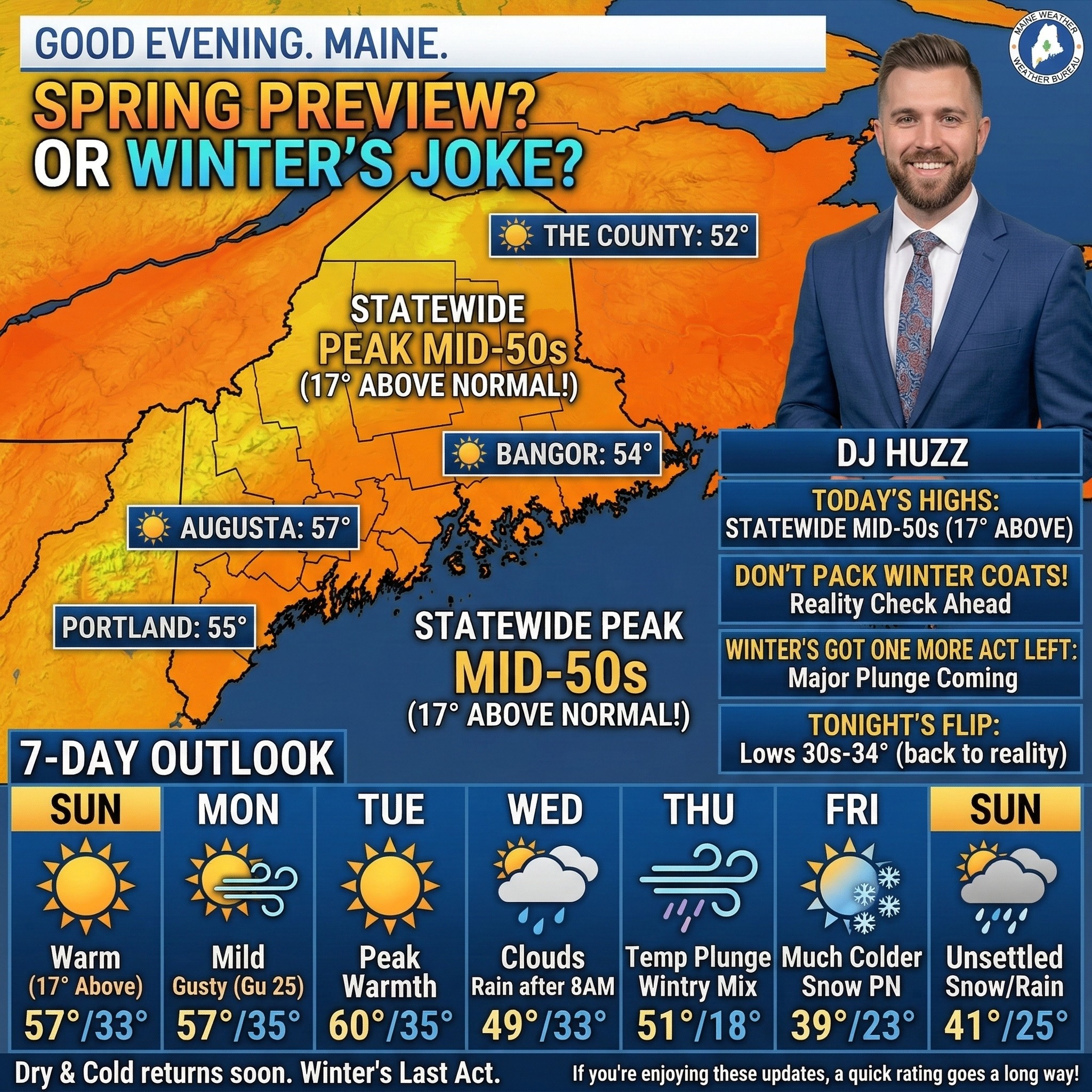
Good evening. Maine. I'm DJ Huzz. The weather's playing a joke on us today. Step outside and you'll swear it's April. We're hitting the mid-50s statewide — that's 17 degrees warmer than normal for early March. Portland peaks near 55. Augusta climbs to 57. Bangor reaches 54. Even The County hits 52. This is the kind of warmth that tricks you into packing away your winter coat. Don't fall for it. Tonight we slide back to reality. Lows drop to the low 30s under mostly clear skies. Portland settles at 33. Augusta cools to 34. Bangor falls to 30. Light southwest winds around 5 to 10 miles an hour. Monday keeps the mild streak alive. Highs climb back to the low-to-mid 50s. Portland hits 57. Augusta reaches 53. Bangor tops out at 55. Mostly sunny, but southwest winds pick up — gusts to 25 miles an hour. Monday night lows dip to the mid-30s. Tuesday brings the warmest day of the week. Highs push into the upper 50s across the board. Portland reaches 59. Augusta hits 60. Bangor climbs to 59. Sunny skies dominate. Light winds. Tuesday night lows settle in the mid-30s. For the rest of the week. Wednesday brings clouds and rain, especially after 8 A.M. Highs in the mid-40s to low 50s. Thursday turns active — rain likely, some heavy, with a wintry mix possible inland. Then a cold front crashes the party. Temperatures plunge fast. Thursday night drops to the teens and low 20s. Friday turns much colder. Highs only reach the upper 30s to low 40s. Another system rolls in Friday night into Saturday — snow and rain possible. The weekend stays unsettled with temperatures closer to normal. Enjoy the spring preview while it lasts. Winter's got one more act left. See you tomorrow.
Maine Weather: 03-08-2026 Midday
Maine weather update for midday
Maine Weather: 03-08-2026 Midday
Maine weather update for midday
Maine Weather 3/8 Midday - Rain Starting 9 AM
Good afternoon. Maine. I'm DJ Huzz. Spring just showed up early for a test drive. Step outside right now and you're already feeling mid-40s. By this afternoon? We're hitting 57 degrees across most of the state — that's 17 degrees warmer than normal for early March. Not complaining. Down in Portland, you've got some patchy fog and drizzle wrapping up by mid-morning. Then partly sunny skies take over with a high near 54. Southwest winds gust to 25 miles an hour — enough to remind you it's still March. Central Maine sees similar action — Augusta and Waterville hit 57 after some early rain clears. Up in Bangor, scattered showers stick around through late morning before the sun breaks through. You top out at 56. Along the coast and Downeast, it's a touch cooler with more clouds hanging on. Highs reach the upper 40s to low 50s. The Western Mountains see partly sunny skies after early fog burns off, topping out near 48. The County gets patchy fog and scattered showers through midday, with highs near 47. Tonight, mostly clear skies settle in statewide. Lows drop to the low-to-mid 30s — mild for early March. Here's your heads-up for the week ahead. Monday stays mild with mostly sunny skies and highs in the low 50s. Tuesday brings even more warmth — upper 50s to near 60 degrees. Gorgeous spring-like conditions. But Wednesday flips the script. A storm system brings rain, with a chance for mixed precipitation up north. Thursday sees rain likely statewide with a strong cold front sweeping through. By Friday, highs crash back to the upper 30s to low 40s with a chance for snow showers. Saturday stays chilly with lingering snow chances. One more thing — clocks spring forward tonight. You lose an hour of sleep, but we gain daylight. Sunrise tomorrow is at 7:07 A.M., sunset at 6:39 P.M. Enjoy the warmth while it lasts. See you this evening.
Maine Weather 3/8 Morning - Rain Starting 3 AM
Good morning. Maine. I'm DJ Huzz. Step outside right now and you might forget it's still winter. We're sitting at 46 degrees after an overnight low of 39. That's 16 degrees warmer than usual for early March. And it feels like spring decided to show up early. Today pushes us to 56 degrees under partly sunny skies. Those patchy showers and fog? They'll clear out by late morning. Southwest winds gust to 25 miles an hour, so hold onto your hat if you're out for a walk. Tonight drops back to the low 30s statewide. Clear and calm. Monday keeps the warmth rolling. Portland hits 54. Bangor reaches 52. And even The County climbs to 49 under mostly sunny skies. Southwest breezes gust to 25 again. Tuesday is the star of the week. Sunshine pushes the coast near 60 degrees. Augusta tops out at 62. Bangor hits 60. And the mountains reach the mid 50s. This is as good as it gets. Then Wednesday flips the script. A storm system swings in from the Great Lakes bringing rain statewide. The County could see a mix of sleet and freezing rain as cooler air filters back in. Highs only reach the low to mid 40s. Thursday stays wet with rain likely and highs in the upper 40s to low 50s. Behind that system, temperatures crash Thursday night into Friday. We're talking single digits and teens in the mountains, low 20s along the coast. Friday brings sunshine but much colder air. Highs struggle to reach the upper 30s to low 40s. One quick note. Spring forward tonight. Set those clocks ahead one hour before bed. See you this afternoon.
Maine Weather 3/7 Evening - Foggy, Frosty, Fabulous!
Good evening. Maine. I'm DJ Huzz. Step outside and you’ll feel that familiar raw dampness in your bones. We’re sitting at 39 degrees under a stubborn gray overcast. It feels colder than the thermometer says, folks. But here’s the surprise — we’re actually winning today. Today’s high hits 43 degrees, which is 11 degrees above normal for early March. Spring is definitely trying to kick the door down. Down along the coast. Portland is holding at 43 degrees with a light south wind at 10 miles an hour. Don’t let the sun fool you; it feels like 32 with that damp air settling in. You’ll see drizzle after 9 PM, then steady rain moves in between midnight and 5 AM. Temperatures actually rise overnight, climbing from 40 to 47 by dawn. Head inland to Augusta and Waterville. And patchy fog develops this afternoon with highs near 40. That fog lingers into the evening before rain takes over after midnight. Like the coast, lows start in the upper 30s then warm into the mid-40s by Sunday morning. Bangor and the Penobscot region are seeing fog and a slight chance of rain this afternoon at 41 degrees. Rain becomes likely after 9 PM with lows around 36, rising to 43 by morning. Over in the Western Mountains, it’s mostly cloudy at 43 degrees with a slight chance of rain today. Look for drizzle tonight with lows around 39, warming to 47 overnight. Up in The County, it’s gray with highs around 40. Rain becomes likely tonight as temperatures rise from 36 to 42 by morning. The Midcoast and Downeast follow the same pattern — fog today, rain tonight. And temperatures climbing from the mid-30s to around 43. In Here’s your heads-up for week ahead, sunday brings a break with partly sunny skies and highs in the 50s. Monday and Tuesday get even warmer — we’re talking upper 50s to near 60, potentially record-breaking warmth. But Wednesday brings a system change — clouds move in with rain likely and highs dropping back to the 40s. Thursday stays wet with rain mixing to snow up north. Friday clears out but cools down significantly into the 30s. This warmth is going to decimate our snowpack. Southern Maine might lose it all, while the north holds onto patches in the shade. And with Maine Maple Sunday just 8 days away, this warmup could get those sap buckets flowing early! We’re gaining daylight fast, too — nearly 3 minutes every day. Sunrise was at 6:09 AM. And we’ll see sunset at 5:38 PM. Grab your umbrella before you head out tonight. You'll need it. See you tomorrow.
Maine Weather 3/7 Midday - Spring Sneeze in March
Good afternoon. Maine. I'm DJ Huzz. Step outside today and you'll feel that classic early-March battle. Spring is trying to push winter out the door, but winter isn't leaving without a fight. Portland is sitting at 43 degrees right now, already running 11 degrees warmer than usual. You'll notice a breeze at 10 miles an hour, gusting to 25, shoving that mild air inland. Head up to Bangor. And it’s a touch cooler at 41 degrees. You might see some light rain this afternoon, though it's only a slight chance. The wind is really howling there, gusting to 23 miles an hour — hold onto your hat. Over in the Western Mountains, you're at 43 degrees with just a after 5 PM. Down east, the ocean keeps things damp at 40 degrees, with fog rolling in off the water. In Here's surprise tonight, temperatures actually rise while you sleep. Portland drops to 40 this evening, but climbs back to 47 by sunrise. Rain moves in between midnight and 5 AM. It's the same story in Augusta, rising from 39 to 45 overnight. Bangor warms from 36 to 43 by morning with rain likely. Even the Western Mountains climb from 39 to 47. This isn't your typical freeze — we're thawing fast. Sunday brings a real spring tease. Portland hits 54 degrees — a solid 14 degrees above normal. Augusta hits 56. Bangor reaches 55. And the mountains get to 48. It will feel like a gift. Looking ahead. Monday and Tuesday stay unseasonably warm, near 60 degrees. But Wednesday brings a wildcard. A storm moves in. And confidence is low on who gets rain versus snow. Northern Maine has the best shot at seeing sleet or snow, while the coast likely sees rain. By Friday, we cool back down, but this warmth will decimate the snowpack. If you're heading to the coast, watch for dense fog this afternoon. Visibility could drop fast. See you this evening.
Maine Weather 3/7 Midday - Foggy Pea Soup Day
Good afternoon. Maine. I'm DJ Huzz. Step outside and you'll feel that unmistakable early March dampness. We're sitting at 38 degrees under a gray sky this morning. But Portland is climbing to 45 degrees today. That's 11 degrees above normal. And with maple sugaring season just 8 days away, this warmth is melting our snowpack fast. The state is having two different days today. Down along the coast. Here comes a foggy, damp afternoon near 45 degrees. That south wind at 10 miles an hour pulls in mild air, but it feels raw. Head inland to Augusta. And you top out at 41 with areas of fog. But up north? that's where the wind takes over. Bangor sits at 41, but gusts to 23 miles an hour make it feel colder. And in The County, you're lucky to hit 40 with that wind howling at 16 miles an hour. Tonight is where things get interesting. That mild air wins the battle. Temperatures actually rise after midnight. Portland climbs from the 30s to near 47 by sunrise. But rain moves in statewide after 10 PM. It starts as drizzle, then turns steady by midnight. Northern Maine could see up to a quarter-inch of rain. With that deep snowpack, we're watching for potential ice jams on the rivers. Sunday brings a serious warm surge. Highs hit the 50s—53 in Portland, 55 in Augusta. And 56 in Bangor. That's 15 degrees above normal. Monday and Tuesday stay downright spring-like, flirting with 60 degrees. But winter isn't done yet. A storm rolls in Wednesday. Right now, rain looks likely for most of us, but up north you could see sleet or snow mixing in. By Friday, we're back to the 30s and 40s. This is the mildest stretch we've seen in months. But don't put the shovel away just yet. If you're tapping trees next weekend, you might be doing it in a raincoat. See you this evening.
Maine Weather 3/7 Morning - Foggy Sleet Surprise
Good morning. Maine. I'm DJ Huzz. Step outside and you'll feel that damp chill cutting right through your jacket. We're waking up to fog so thick in spots you might think you're in a cloud, with temperatures hovering right around freezing. That half-inch of snow from yesterday? It's already turning slushy as we get our first real taste of March's back-and-forth between winter and spring. In Here's what's headed our way, **A Winter Weather Advisory** is in effect for northern and central Maine until 1 P.M. We're talking freezing drizzle and patchy freezing rain through mid-morning—just enough to make untreated roads and sidewalks slick. By late morning, that icy mix changes to plain rain as temperatures climb well above freezing. **Down along the coast**. Portland starts at 33 degrees with areas of fog. You'll see that fog linger through mid-morning before temperatures rise to a very un-March-like 46 degrees—7 degrees above normal. Winds shift to the south and pick up to 10 miles an hour with gusts to 25. Tonight? Mild. Lows only drop to 41, with more drizzle possible overnight. **Head north to Bangor**. And you're waking up to 22 degrees with patchy fog. But here's the twist: by this afternoon, you'll hit 45—nearly 20 degrees warmer than this morning. Rain moves in by late morning, turning heavy at times. Tonight stays unusually warm too, with lows around 35 and steady rain tapering to drizzle. **The mountains?** A whole different story. Freezing rain likely through mid-morning—up to a tenth of an inch of ice possible—before changing to plain rain. Highs reach 47, but tonight drops back to 32 with clearing skies. In **the big picture this weekend, ** We're gaining nearly 3 minutes of daylight. And you can feel spring trying to break through. Sunday brings a taste of what's coming—highs in the 50s for many spots. But don't put away the winter gear just yet. By midweek, we're watching a storm system that could bring anything from rain to snow to a wintry mix, depending on its track. **A perfect day to get outside and soak up that extra sunlight. In **monday tuesday, ** Near-record warmth continues. We're talking highs in the upper 50s—yes, in March. Bangor could challenge its record of 59 degrees set back in 2016. In **wednesday through friday, ** Reality check. A storm system moves in, bringing rain that could mix with or change to snow, especially in northern and mountainous areas. Temperatures drop back to the 30s and 40s by Thursday. And yes, we might even see some accumulation in The County by Friday morning. In **one last note for maple syrup lovers, ** Sugaring season officially kicks off in just 8 days. With this warmup, the sap should really start flowing—great news for local producers! See you tomorrow. See you this afternoon.
Maine Weather 3/7 Morning - Foggy Spring Fool's Day
Good morning. Maine. I'm DJ Huzz. Step outside and you'll feel that damp chill cutting right through your jacket. That's classic early March in Maine. We've got fog clinging to the coast, half an inch of fresh snow lingering from yesterday. And temperatures that are playing hard to get this morning. But here's the twist: spring is making its move. Today's high of 47 degrees in Portland is 7 degrees above normal — and that's just the opening act. Down along the coast. Portland wakes up to areas of fog and a chance of drizzle before 9 A.M. By afternoon, you'll actually feel that hint of spring. Highs reach 46 degrees with south winds gusting to 25 miles an hour. But don't put away the umbrella just yet. Rain likely returns overnight, with temperatures doing something unusual. We're rising from 41 at sunset to 47 by sunrise Sunday. That's right, we're actually getting warmer after dark. Head north to Augusta and Waterville. And you'll find a different story unfolding. Freezing rain and sleet make for a tricky morning commute before changing to plain rain by late morning. Highs still climb to 46 degrees — well above normal — but the real drama happens overnight when rain becomes likely again. One silver lining: Sunday brings mostly cloudy skies and a high near 55. That's 15 degrees above average for early March. The mountains are where winter makes its last stand today. Freezing rain is likely through mid-morning in the Western Mountains. Up to a tenth of an inch of ice could create slick spots on untreated roads. Highs only reach 47 degrees there, but overnight we see rain moving in with temperatures actually rising to around 40. Sunday brings partly sunny skies and a high near 52 — still 12 degrees above normal for this time of year. Up in Aroostook County, they're seeing the most dramatic warmup. After starting at just 18 degrees this morning, temperatures soar to 44 by afternoon. That's a 26-degree jump in 12 hours. Rain becomes likely tonight with temperatures continuing to rise overnight. Sunday brings rain showers likely and highs near 46 — nearly 10 degrees above normal for The County in early March. Looking ahead, we've got a wild temperature rollercoaster coming. Monday and Tuesday bring record-challenging warmth. We're talking highs in the upper 50s to near 60 degrees statewide. That's 20 degrees above normal for this time of year. But don't get too comfortable. By Wednesday, a storm system moves in with rain likely, followed by a sharp cooldown. Thursday could even bring a chance of snow mixing in as temperatures plummet back to the 30s and 40s. The big picture? This is classic Maine March weather. We're gaining nearly 3 minutes of daylight each day now, the maple sugaring season kicks off in just 8 days. And the spring equinox is only 13 days away. But as today proves, winter isn't ready to leave without a fight. Charge your phone before you head out tonight — that cold drain catches everyone off guard this time of year. See you tomorrow. See you this afternoon.
Maine Weather 3/6 Morning - 12° Below Normal
Good morning. Maine. I'm DJ Huzz. If you stepped outside this morning, you felt winter's last stand. Snow's been falling overnight, coating roads from Portland through the foothills. We've picked up 2 to 4 inches, with the heaviest wrapping up by mid-morning. That commute? Take it slow. Here's the temperature story. We're stuck in a cold trap today. Portland tops out at 35 degrees. Augusta hits 33. Bangor reaches 35. The coast sits at 33. Western Mountains struggle to 30. Up in The County? You'll be lucky to see 29. That's 12 degrees below normal for early March — spring's knocking, but winter's not answering. Tonight brings the tricky part. Freezing drizzle develops across central and northern Maine. Augusta and Waterville see patchy fog and ice by evening. Bangor gets the same treatment after midnight. Lows drop to the upper 20s south, but The County plunges to 18 degrees. Untreated roads could get slick fast. Saturday morning is when things get interesting. A Winter Weather Advisory kicks in at 6 A.M. For northern and Downeast Maine. Freezing rain and sleet mix across the north until early afternoon, with ice accumulations up to a tenth of an inch. By afternoon, temperatures finally climb above freezing and everything switches to rain. Highs reach the low 40s statewide. Here's your weekend outlook. Sunday brings a warm-up — low 50s with partly sunny skies. Monday pushes into the mid 50s with sunshine. Tuesday could hit 56 to 58 degrees, possibly challenging daily records. But that warmth won't last. A storm arrives Wednesday with rain and snow likely, followed by a sharp cooldown Thursday. Watch those roads this weekend, folks. See you tomorrow. For the extended outlook, check the latest forecast See you tomorrow.
Maine Weather 3/5 Evening - Snow Day Dreams
Good evening. Maine. I'm DJ Huzz. Step outside and you'll feel that classic late-winter chill. With overcast skies overhead. We're sitting at 32 degrees right now. That's five degrees colder than our usual March high of 40. The calendar says spring is close, but the air still says winter. Here's the drama for tonight. A coastal system is spinning up. Snow moves into the Portland area around 8 P.M. It spreads inland overnight. Expect a coating to an inch in the city. Head north to Augusta and you'll see a chance for snow after 5 A.M. The mountains stay mostly cloudy and cold. Down in The County, it's a different story. Lows drop to minus 2 degrees. That's dangerously cold. Friday brings more clouds. Portland tops out near 34 degrees. Snow lingers in the morning before ending. The central region sees a high near 34. Any snow showers end quickly there. Up in Bangor, expect a high of 35 under gray skies. The mountains struggle to reach 30. The County warms slightly to 29 degrees. Friday night is when things get tricky. A warm front pushes in. Temperatures hover right at freezing. This creates a risk for freezing drizzle or patchy fog. It could make for some slick spots on the roads by Saturday morning. You'll want to watch your step. Looking ahead, the pattern shifts fast. Saturday brings drizzle and highs in the 40s. We jump into the 50s by Sunday. Monday looks sunny and beautiful with a high near 54. We might even hit 58 on Tuesday. That's a massive warm-up. It could start melting some of our snowpack. Another system moves in Wednesday. This one brings a chance for rain and snow showers. Highs drop back to the 40s. See you tomorrow. Take care For the extended outlook, check the latest forecast See you tomorrow.
Maine Weather March 5 Midday - Cloudy
Good afternoon. Maine. I'm DJ Huzz. Step outside right now and you're feeling 36 degrees under clear skies. Feels almost calm. But winter's got one more card to play. In the next 24 hours. The South Coast takes the hit tonight. Portland climbs to 35 this afternoon as clouds roll in. Then right around 6 P.M., the snow starts falling. It comes down heaviest around 1 A.M. — expect 2 to 4 inches by sunrise. Friday morning's commute? Plan extra time. Push inland to Augusta and the story softens. You'll hit 30 degrees today. Snow holds off until after 1 A.M. and you're looking at less than half an inch total. Bangor and points north mostly dodge this one. Bangor tops out at 28 under mostly cloudy skies. No significant snow. Downeast stays dry too with highs near 30. The Western Mountains see 27 today, then drop to 12 overnight. And up in The County? Bundle every layer you own. Highs near 18. Lows tonight crash to zero. Tonight's full moon will light up any fresh snow like a postcard. Fun fact — on this day back in 1971. Portland got buried under 26 inches. Today's storm is tame by comparison. Saturday flips the script completely — rain and mid-40s. Sunday we crack 50. By Tuesday? Near 60 degrees under sunny skies. That's a 40-degree swing in five days. Classic Maine. In Sunrise hits at 6, 12 A.M. Sunset at 5:35 P.M. We're gaining nearly three minutes of daylight every day now. If you've got early plans tomorrow, charge your phone tonight and scrape that windshield before you leave. For the extended outlook, check the latest forecast as confidence improves. That's your forecast — we'll be back tomorrow.
Maine Weather March 5 Morning - Unseasonably Cold
Good morning. Maine. I'm DJ Huzz. Right now. Maine's split wide open. Portland's sitting at 29 degrees. Bangor's at 20. And out in The County? A brutal 8 degrees with wind chills near minus 5. That's a 21-degree spread before you've finished your first coffee. In the next 24 hours. Today stays quiet. Mostly cloudy skies. Portland climbs to 35 degrees — about 5 degrees below normal for early March. The mountains and northern spots struggle to crack the upper 20s. Enjoy the calm while it lasts. Tonight. Everything changes. Snow arrives along the South Coast after 7 P.M. Portland's looking at 2 to 4 inches by morning, with the heaviest snow falling around 1 A.M. That's prime sleeping hours, so you'll wake up to a fresh coat. Augusta might see a dusting. Areas north of there stay dry. Friday brings more snow showers to southern areas, possibly mixing with sleet. Highs hold in the low 30s. If you're commuting along the coast, give yourself extra time. Then comes the warm-up. Saturday temperatures climb into the 40s. By Tuesday, we could hit 58 degrees in Portland. That's nearly 20 degrees above normal. Classic March — winter one day, spring the next. Maple sugaring season is just 10 days away. And the spring equinox arrives in about two weeks. One more note — tonight's Full Moon rises at sunset. If you're up late watching the snow fall, you'll have plenty of light to see it. Here's your heads-up for the week ahead. Saturday and Sunday stay mild in the 40s. Monday climbs into the low 50s. Tuesday hits that 58-degree peak. Then we cool back down to reality by Wednesday. Northern Maine, enjoy the quiet while southern areas dig out tomorrow. For the extended outlook, check the latest forecast as confidence improves. That's your forecast — we'll be back tomorrow.
Maine Weather March 4 Evening - Unseasonably Warm
Good evening. Maine. I'm DJ Huzz. That inch and a half of snow yesterday already feels like a distant memory. Step outside right now and you'll find 47 degrees on the thermometer. That's 7 degrees above normal for early March. Winter is loosening its grip. In the next 24 hours. Here's the breakdown for today. Southern and coastal areas from Portland through the Midcoast top out around 45 degrees. Central Maine reaches 47. Bangor hits 47 as well. The Western Mountains sit cooler at 40 degrees with a west wind around 10 miles an hour. But head to The County and it's a different world. Aroostook starts mild at 43 degrees this afternoon. Then the bottom drops out. Scattered snow showers move in after 8 P.M. Temperatures plummet to 7 degrees overnight. Yes, single digits. Wind chills dip to minus 3. The rest of the state stays dry tonight with partly cloudy skies. Lows range from the low 20s to around 26 degrees along the coast. Thursday brings a brief cooldown. Highs only reach the mid-30s in central areas and low 30s Downeast. Bangor struggles to hit 30. The County barely makes it to 17 degrees. Thursday night is when things get interesting. A storm slides south of us. Portland and coastal areas see snow developing after 7 P.M., mixing with sleet overnight. Expect 1 to 2 inches of accumulation. Central Maine picks up lighter amounts. Friday that system lingers with snow and sleet in the morning, tapering off by afternoon. Then the pattern flips. Saturday through Tuesday we warm up fast. Highs climb into the upper 40s Sunday, then 50s Monday. And near 60 degrees by Tuesday. Maple sugaring season is just 11 days away and the weather will cooperate. One more thing — look up tonight. It's a full moon. Sunrise was at 6:14 this morning and sunset comes at 5:34 this evening. We gained nearly 3 minutes of daylight today. For the extended outlook, check the latest forecast as confidence improves. That's your forecast — we'll be back tomorrow.
Maine Weather March 4 Midday - Unseasonably Warm
Good afternoon. Maine. I'm DJ Huzz. That inch and a half of snow yesterday already feels like a memory. Step outside today and you'll find sunshine with highs in the mid to upper 40s. That's about 7 degrees above normal for early March. In the next 24 hours. Portland reaches 46 degrees under sunny skies. Augusta and Bangor both climb to 47. The Western Mountains stay cooler at 39. But up in Aroostook County, enjoy that 43-degree high. Because tonight brings a dramatic change. A full moon rises over a rapidly cooling state. Lows plunge to 24 in Portland, 21 in Bangor. The County drops to 9 degrees with snow likely after 7 P.M. Thursday turns sharply colder. A backdoor cold front drops highs into the teens up north, upper 20s in Bangor. And only 33 to 36 degrees in Portland. Then the pattern gets interesting. Snow spreads across the state Thursday night into Friday. Portland could see 1 to 3 inches. Central areas pick up around an inch. A wintry mix of sleet and freezing rain is possible Friday night. But spring fights back this weekend. Saturday highs surge into the upper 40s. Sunday and Monday bring 50s statewide. That snow won't linger long. On this date in 1971. Portland got buried under 26 inches of snow. Quite the contrast today. Sunrise at 6:14, sunset at 5:34. We're gaining nearly 3 minutes of daylight daily. For the extended outlook, check the latest forecast as confidence improves. That's your forecast — we'll be back tomorrow.
Maine Weather March 4 Morning - Snow
Good morning. Maine. I'm DJ Huzz. That fresh coating of snow on the ground? About an inch and a half fell overnight. But don't get too comfortable. Winter is about to pull a disappearing act this afternoon. We're looking at a serious warm-up. Portland hits 46 degrees today. That's 7 degrees warmer than usual for early March. In the next 24 hours. Augusta and Bangor aren't far behind at 47. Downeast and the Midcoast bask in 45 under mostly sunny skies. The Western Mountains are the cool spot today, topping out at 39. Up in The County, you'll hit 43 degrees, though a breeze picks up with gusts to 25 miles an hour. Enjoy the thaw while you can. Because the bottom drops out tonight. The County plunges into the single digits — down to 9 degrees. The rest of the state settles into the low 20s under partly cloudy skies. Thursday brings a reality check. A backdoor cold front crashes the party. Bangor struggles to reach 28. Downeast sees 30. And up north? You're looking at a high of just 14 degrees. That's the high, folks. The unsettled weather returns Thursday night. Snow moves into southern and central areas. Portland could see 1 to 3 inches. Friday brings a messy mix statewide — snow, sleet. And freezing rain. Expect slick travel Friday night into early Saturday. But then the pattern flips. Sunday through Tuesday, we're back in the 50s. Highs near 53 Monday and 56 Tuesday. That snow pack isn't going to survive. Tonight's full moon rises at sunset. And on this day in 1971. Portland got walloped with 26 inches of snow. So a dusting overnight? We'll take it. Sunrise at 6:14, sunset at 5:34. We're gaining nearly three minutes of daylight. Keep that heavy coat handy for tomorrow. For the extended outlook, check the latest forecast as confidence improves. That's your forecast — we'll be back tomorrow.
Maine Weather March 4 Evening - Unseasonably Warm
Good evening. Maine. I'm DJ Huzz. That snow falling outside your window? It's on its way out. About an inch and a half fell overnight, but the system exits before daybreak. By the time you're listening, skies are already clearing. In the next 24 hours. In Here's headline, today turns downright pleasant. Portland hits 46 degrees under sunny skies. That's 7 degrees above normal for early March. Augusta reaches 47. Bangor also tops out at 47. Downeast areas see a high of 45 after the morning snow clears. The Western Mountains reach 39. And Aroostook County hits 43. But don't get comfortable up there. Tonight, temperatures crash. Portland drops to 26. Augusta falls to 24. Bangor plunges to 21. The mountains sit at 24. And The County? A bone-chilling 9 degrees overnight, with snow developing after 7 P.M. Thursday brings a reality check. A backdoor cold front sweeps through, dropping highs into the 30s for most areas. The north stays in the teens. Then Thursday night into Friday. Our next storm arrives. Expect snow across much of the state, possibly mixing with sleet and freezing rain along the coast. The weekend turns messy. Saturday features a wintry mix transitioning to rain as temperatures climb into the upper 40s. Sunday clears out with highs near 50. Early next week looks genuinely spring-like. Monday brings sun and 53 degrees. Tuesday could hit 56. That's 16 degrees above normal. By the way, on this date in 1971. Portland got walloped with 26 inches of snow. We're getting off easy today. Full moon tonight if skies clear in time. For the extended outlook, check the latest forecast as confidence improves. That's your forecast — we'll be back tomorrow.